IMAGES TAKEN NEAR TO
Swan Lane, ASHFORD, TN27 0PJ
Introduction
This page details the photographs taken nearby to Swan Lane, TN27 0PJ by members of the Geograph project.
The Geograph project started in 2005 with the aim of publishing, organising and preserving representative images for every square kilometre of Great Britain, Ireland and the Isle of Man.

There are currently over 7.5m images from over14,400 individuals and you can help contribute to the project by visiting https://www.geograph.org.uk
Image Map (Loading...)


Getting Data...Please wait
Leaflet Map data © OpenStreetMap
Images are licensed for reuse under creativecommons.org/licenses/by-sa/2.0
Notes
- Clicking on the map will re-center to the selected point.
- The higher the marker number, the further away the image location is from the centre of the postcode.
Image Listing (43 Images Found)
Images are licensed for reuse under creativecommons.org/licenses/by-sa/2.0
Image
Details
Distance
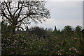
3
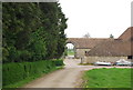
Sheerland Farm Oast, Swan Lane, Sheerland Farm, Pluckley, Kent
Image: © Oast House Archive
Taken: 29 Jul 2009
0.09 miles
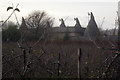
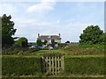
5
Stable block, Sheerland Farm
Grade II listed. http://www.britishlistedbuildings.co.uk/en-181099-stables-to-the-north-east-of-sheerland-h
Image: © N Chadwick
Taken: 15 Apr 2011
0.11 miles
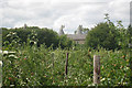
6
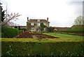
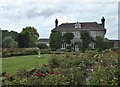
Sheerland House, near Pluckley
This attractive and symmetrical house with the ubiquitous Dering windows of Pluckley and Little Chart is seen here from the Greensand Way between Pluckley and Little Chart. Sheerland House forms part of Sheerland Farm. For a little more information on the house see http://www.geograph.org.uk/photo/5225254
The Greensand Ridge provides the highest points in south-east England, rather than the North and South Downs as many people would suppose. The Greensand Way runs from Haslemere in Surrey to Ham Street on the edge of Romney Marsh.
Image: © Marathon
Taken: 29 Aug 2017
0.12 miles
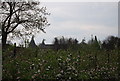
7
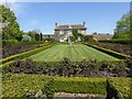
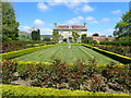
Sheerland House
Grade II listed farmhouse and garden.
Image: © Oliver Dixon
Taken: 8 May 2016
0.12 miles
8
Sheerland House
Grade II listed with Dering windows. http://www.britishlistedbuildings.co.uk/en-181097-sheerland-house-pluckley
Image: © N Chadwick
Taken: 15 Apr 2011
0.13 miles
9
Sheerland House, near Pluckley
This attractive and symmetrical house with the ubiquitous Dering windows of Pluckley and Little Chart is seen here from the Greensand Way between Pluckley and Little Chart. Sheerland House forms part of Sheerland Farm. Dering windows are found in Pluckley and surrounding areas, and named after the Dering family. They are identified by their round tops above each casement. It is said that during the Civil War (1642-1652) one of the Royalist members of the Dering family escaped through one of these windows. Considering them lucky, Sir Edward Cholmeley Dering had all the windows on the estate (which included much of the village) replaced with the same style windows. For a little more information on the house see http://www.geograph.org.uk/photo/5225254
The Greensand Ridge provides the highest points in south-east England, rather than the North and South Downs as many people would suppose. The Greensand Way runs from Haslemere in Surrey to Ham Street on the edge of Romney Marsh.
Image: © Marathon
Taken: 30 Apr 2022
0.13 miles
10
Sheerland Farmhouse, Pluckley
A grade II listed building with the round-topped Dering windows. It is part of the home farm of the Surrenden Dering estate and was built in 1813.Dering windows are found in Pluckley and surrounding areas, and named after the Dering family. They are identified by their round tops above each casement.
It is said that during the civil war (1642-1652) one of the Royalist members of the Dering family escaped through one of these windows. Considering them lucky, Sir Edward Cholmeley Dering had all the windows on the Dering estate made to the same pattern.
Image: © pam fray
Taken: 27 Jul 2020
0.13 miles