IMAGES TAKEN NEAR TO
Ruckinge, ASHFORD, TN26 2NY
Introduction
This page details the photographs taken nearby to TN26 2NY by members of the Geograph project.
The Geograph project started in 2005 with the aim of publishing, organising and preserving representative images for every square kilometre of Great Britain, Ireland and the Isle of Man.

There are currently over 7.5m images from over14,400 individuals and you can help contribute to the project by visiting https://www.geograph.org.uk
Image Map
Images are licensed for reuse under creativecommons.org/licenses/by-sa/2.0
Notes
- Clicking on the map will re-center to the selected point.
- The higher the marker number, the further away the image location is from the centre of the postcode.
Image Listing (87 Images Found)
Images are licensed for reuse under creativecommons.org/licenses/by-sa/2.0
Image
Details
Distance
1
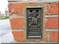
Ordnance Survey Flush Bracket 11922
This can be found on the external roadside wall of the Old Post Office - now a private dwelling.
For more detail see : http://www.bench-marks.org.uk/bm11854
Image: © Peter Wood
Taken: 13 Feb 2016
0.01 miles
2
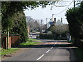
View along Ham Street Road
The Blue Anchor pub http://www.geograph.org.uk/photo/24478 is visible in the distance.
Image: © Nick Smith
Taken: 16 Mar 2009
0.02 miles
3
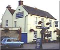
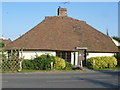
Blue Anchor Pub, Ruckinge
This pleasant public house is located opposite the former post office stores, another casualty of the dreaded supermarkets. Ruckinge has an interesting history with the Ransley brothers, notorious smugglers, reputed to be buried in the churchyard of St Mary Magdalene.
Image: © Adam Colton
Taken: 6 Jul 2005
0.02 miles
4
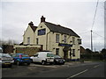
The Blue Anchor Pub, Ruckinge, Ashford
Ruckinge, ASHFORD TN26 2NY close to The Royal Military Canal
Image: © canalandriversidepubs co uk
Taken: 13 Mar 2010
0.03 miles
5
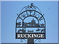
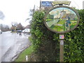
The village sign at Ruckinge
The horse of Kent stands atop the village sign, with an anchor, a viking helmet, the Fleur de Lis, cattle, the church and sheep, a tractor, stocks and a highway robbery all indicating the history and present life of the village. This is a most interesting and attractive sign. Its setting can be seen at http://www.geograph.org.uk/photo/4058899
Image: © Marathon
Taken: 23 Jun 2014
0.03 miles
6
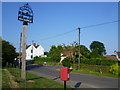
Ruckinge Village Sign
One of two village signs in the village on the B2067 Hamstreet Road. Behind is Ramsley Green and in the background is St. Mary Magdalene Church.
On the post is a metal plaque which reads 'VILLAGE SIGN EXPLANATION PLATE.November 2007.
CENTRE: St Mary Magdelene,1086.(sic)
BOTTOM: Averling and Porter built the first steam roller.
Thomas Averling lived at Court Lodge.
Richard Porter farmed at Langdon.
Ransley brothers, smugglers and petty thieves hung at Penenden Heath in 1800.
Wooden headboard in Churchyard.
CIRCLE: Saxon Shoreway footpath.
Royal Military footpath and marshland, cattle on higher ground.
Scout and Guide Centre.
The blue Anchor Pub,1850.
TOP: Kent Invicta.'
Note: Spelling of St Mary Magdalene is spelt St Mary Magdelene on the plaque.
Image: © David Anstiss
Taken: 21 Feb 2010
0.03 miles
7
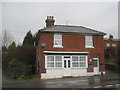
The Old Post Office
On the B2067 Bilsington Road, opposite Marsh Road.
Image: © David Anstiss
Taken: 21 Feb 2010
0.03 miles
8
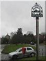
The setting of the village sign for Ruckinge
The village sign is at the eastern end of Ransley Green, next to Hamstreet Road (B2067). A close up of the sign can be seen at http://www.geograph.org.uk/photo/4058883 The Blue Anchor pub can be seen in the distance.
Image: © Marathon
Taken: 23 Jun 2014
0.03 miles
9
Ruckinge Millennium Sign
The second of two village signs in the village. This one is on the B2067 Bilsington Road at the junction of Marsh Road. In the background is the Blue Anchor Pub. The sign has a small information plaque below which reads
'RUCKINGE MILLENNIUM SIGN. The millennium sign incorporates many features to depict life in the village. For over 800 years the church has dominated the hamlet built above the old shoreline. The canal, dug in 1806 as a defence against Napoleon, separates the houses from Romney Marsh. The old mill was demolished in 1910. The wooden markerboard of the Ranlsey family grave represents the illegal activity of smuggling carried on throughout the centuries in the locality. The Ordnance Survey, founded in 1791, celebrated its 200th anniversary at Ruckinge. A time capsule was buried, south east of the church, at the point where General Roy created the first baseline of verification, for the purposes of triangulation, between Dymchurch and Ruckinge in 1787. The hiker is using one of the many footpaths that cross the Parish. Sheep were once an important part of the local economy. The frame was constructed from a local oak tree blown over in the great storm of 1987 which destroyed thousands of trees in Ruckinge.'
Image: © David Anstiss
Taken: 21 Feb 2010
0.04 miles
10
Ransley Cottage, Ruckinge
Ransley Cottage is on the other side of Hamstreet Road (B2067) from the village sign, which is next to Ransley Green.
Image: © Marathon
Taken: 23 Jun 2014
0.05 miles