IMAGES TAKEN NEAR TO
Appledore, ASHFORD, TN26 2DP
Introduction
This page details the photographs taken nearby to TN26 2DP by members of the Geograph project.
The Geograph project started in 2005 with the aim of publishing, organising and preserving representative images for every square kilometre of Great Britain, Ireland and the Isle of Man.

There are currently over 7.5m images from over14,400 individuals and you can help contribute to the project by visiting https://www.geograph.org.uk
Image Map
Images are licensed for reuse under creativecommons.org/licenses/by-sa/2.0
Notes
- Clicking on the map will re-center to the selected point.
- The higher the marker number, the further away the image location is from the centre of the postcode.
Image Listing (130 Images Found)
Images are licensed for reuse under creativecommons.org/licenses/by-sa/2.0
Image
Details
Distance
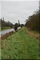
1
The Royal Military Canal at Priory Lands
Image: © Stefan Czapski
Taken: 3 Sep 2012
0.01 miles
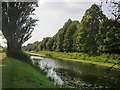
4
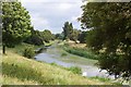
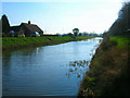
The Royal Military Canal, Romney Marsh, Kent
The Royal Military Canal ran between Hythe and Rye and was completed in 1809. It was built as a defensive line to guard against a threatened invasion by Napoleon. Every five hundred yards there is a kink in the canal, allowing guns mounted on the northern bank to fire along the length of the canal at anyone trying to cross.
Image: © Ron Strutt
Taken: 29 Jun 2004
0.04 miles
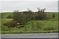
5
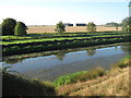
Royal Military Canal and farm barns
As seen from the Royal Military Canal Path near Appledore.
The barns may belong to Priory Farm.
Image: © David Anstiss
Taken: 12 Sep 2010
0.05 miles
7
Royal Military Canal, Priory Lands
Heading out of Appledore before turning south towards Rye.
Image: © Simon Carey
Taken: 8 Apr 2007
0.07 miles
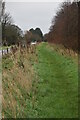
8
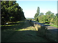
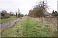
Romney Marsh Canal Path towards Rye
The long distance path leads along an embankment beside the Canal (hidden by the trees on the left) and beside Military Road on the right.
Image: © David Anstiss
Taken: 12 Sep 2010
0.08 miles