IMAGES TAKEN NEAR TO
Mersham, ASHFORD, TN25 7HW
Introduction
This page details the photographs taken nearby to TN25 7HW by members of the Geograph project.
The Geograph project started in 2005 with the aim of publishing, organising and preserving representative images for every square kilometre of Great Britain, Ireland and the Isle of Man.

There are currently over 7.5m images from over14,400 individuals and you can help contribute to the project by visiting https://www.geograph.org.uk
Image Map
Images are licensed for reuse under creativecommons.org/licenses/by-sa/2.0
Notes
- Clicking on the map will re-center to the selected point.
- The higher the marker number, the further away the image location is from the centre of the postcode.
Image Listing (32 Images Found)
Images are licensed for reuse under creativecommons.org/licenses/by-sa/2.0
Image
Details
Distance
1
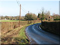
View along the road towards Mersham
Walnut Cottages on the right, the road doesn't appear to have a name at this point.
Image: © Nick Smith
Taken: 17 Jan 2010
0.02 miles
3
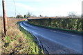
Lane to Broad Oak
Near Walnut Farm.
Image: © Julian P Guffogg
Taken: 30 Dec 2012
0.05 miles
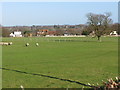
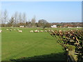
5
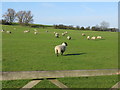
Sheep grazing on the side of Collier's Hill
Image: © Nick Smith
Taken: 17 Jan 2010
0.11 miles
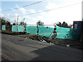
6
Houses under construction
Compared with Image, the ongoing construction of one of the houses can be seen but the other is hidden behind the hoarding. There have been two Ashford Borough Council planning applications relating to this site: 11/00707/AS was for “two replacement dwellings and the creation of a new access and 15/01156/AS, was for the “erection of two detached chalet bungalows (lapsed planning permission 11/00707AS) and creation of new access”.
Image: © John Baker
Taken: 24 Apr 2016
0.13 miles
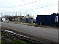
7
Building site, Broad Oak
Compared with Image, the site has been cleared of any trace of them. There have been two Ashford Borough Council planning applications relating to this site: 11/00707/AS was for “two replacement dwellings and the creation of a new access and 15/01156/AS, was for the “erection of two detached chalet bungalows (lapsed planning permission 11/00707AS) and creation of new access”.
Image: © John Baker
Taken: 7 Feb 2016
0.13 miles
8
Demolition of Dilton & Oakfield, Broad Oak
There have been two Ashford Borough Council planning applications relating to these properties: 11/00707/AS was for “two replacement dwellings and the creation of a new access and 15/01156/AS, was for the “erection of two detached chalet bungalows (lapsed planning permission 11/00707AS) and creation of new access”. This is Image in October 2014.
Image: © John Baker
Taken: 17 Jan 2016
0.13 miles
9
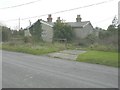
Dilton and Oakfield, Broad Oak
This semi-detached property is becoming overrun by nature.
Image: © John Baker
Taken: 22 Oct 2014
0.13 miles
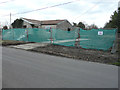
10
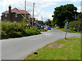
The crossroads at Broad Oak
Compared with Image but viewed from the other direction, the nearer of the two detached chalet bungalows, mentioned in Ashford Borough Council’s planning application 15/01156/AS, as the “erection of two detached chalet bungalows (lapsed planning permission 11/00707AS) and creation of new access”, looks to be almost finished.
Image: © John Baker
Taken: 31 Jul 2016
0.14 miles