IMAGES TAKEN NEAR TO
The Chestnuts, Swan Lane, ASHFORD, TN25 6LH
Introduction
This page details the photographs taken nearby to The Chestnuts, Swan Lane, TN25 6LH by members of the Geograph project.
The Geograph project started in 2005 with the aim of publishing, organising and preserving representative images for every square kilometre of Great Britain, Ireland and the Isle of Man.

There are currently over 7.5m images from over14,400 individuals and you can help contribute to the project by visiting https://www.geograph.org.uk
Image Map
Images are licensed for reuse under creativecommons.org/licenses/by-sa/2.0
Notes
- Clicking on the map will re-center to the selected point.
- The higher the marker number, the further away the image location is from the centre of the postcode.
Image Listing (49 Images Found)
Images are licensed for reuse under creativecommons.org/licenses/by-sa/2.0
Image
Details
Distance
1
The Lees, Ashford Road
Planning permission has been approved, with conditions, by Folkestone and Hythe District Council under application number Y14/0873/SH for a “hybrid application for the redevelopment of land between the A20 and M20 at Sellindge. Application for outline permission (with all matters reserved except access) comprising of 200 dwellings, local mixed use centre containing parish offices (sui generis up to 100m2), and associated storage (sui generis up to 100m2, 40m2 as closed storage and 60m2 as secure outdoor storage) commercial floorspace (A1/A3/A5 uses up to 200m2) together with access form the A20, associated roads, parking, earthworks, open space including attenuation features and landscaping. Full application comprising 50 dwellings, village green and play equipment, access from the A20, associated roads, community car parking, earthworks, open space including attenuation features and landscaping".
Image: © John Baker
Taken: 24 Nov 2019
0.04 miles
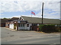
4
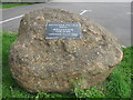
Memorial Stone for Sellindge Village Hall
Millennium carpark on A20 Ashford Road, opened July 2000.
Image: © David Anstiss
Taken: 8 Aug 2009
0.10 miles
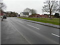
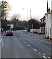
5

St Katherines Crescent
This was Image before it became a through route for all vehicles.
Image: © John Baker
Taken: 16 Jul 2023
0.10 miles
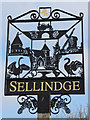
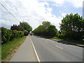
8
Sellindge Village (A20)
The Domesday Book names Sellindge as Sedlinges with two churches a mill , 36 acres of meadow, and a wood for 6 pigs. It is known that William the Conqueror gave the four local manors to Hugo de Montford
In the mid 1650's Oliver Cromwell is recorded as having his horse re-shoed at Stone Hill smithy in the village, he paid 4d.
Image: © Faheem Anwar
Taken: 4 Feb 2020
0.11 miles
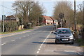
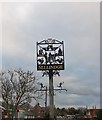
9
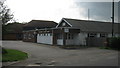
Sellindge Village Hall
On A20 Ashford Road, opposite Sellindge Primary School.
Image: © David Anstiss
Taken: 8 Aug 2009
0.13 miles