IMAGES TAKEN NEAR TO
Rising Road, ASHFORD, TN23 4QG
Introduction
This page details the photographs taken nearby to Rising Road, TN23 4QG by members of the Geograph project.
The Geograph project started in 2005 with the aim of publishing, organising and preserving representative images for every square kilometre of Great Britain, Ireland and the Isle of Man.

There are currently over 7.5m images from over14,400 individuals and you can help contribute to the project by visiting https://www.geograph.org.uk
Image Map
Images are licensed for reuse under creativecommons.org/licenses/by-sa/2.0
Notes
- Clicking on the map will re-center to the selected point.
- The higher the marker number, the further away the image location is from the centre of the postcode.
Image Listing (57 Images Found)
Images are licensed for reuse under creativecommons.org/licenses/by-sa/2.0
Image
Details
Distance
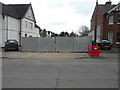
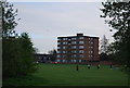
1
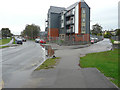
Jemmett Road
This was Image in August 2018 when the site, where the apartment block now stands, was hidden by hoarding. The apartment block is part of a development called the Victoria Quarter, where work is still ongoing.
Planning permission has been granted by Ashford Borough Council under application number 17/00354/AS for a “reserved matters application for the development of 160 dwellings together with access roads, footpaths, drainage, associated car/bicycle parking provision, ground works, landscaping, open space and infrastructure (pursuant to outline approval 11/00405/AS) “.
Image: © John Baker
Taken: 14 Oct 2019
0.08 miles
2
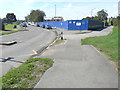
Jemmett Road
The hoarding hides a building site, which will ultimately be called the Victoria Quarter after the development has been completed.
Planning permission has been granted by Ashford Borough Council under application number 17/00354/AS for a “reserved matters application for the development of 160 dwellings together with access roads, footpaths, drainage, associated car/bicycle parking provision, ground works, landscaping, open space and infrastructure (pursuant to outline approval 11/00405/AS) “.
Image: © John Baker
Taken: 17 Aug 2018
0.08 miles
3
Building site, Jemmett Road
Planning permission has been granted by Ashford Borough Council under application number 17/00354/AS for a “reserved matters application for the development of 160 dwellings together with access roads, footpaths, drainage, associated car/bicycle parking provision, ground works, landscaping, open space and infrastructure (pursuant to outline approval 11/00405/AS) “.
The development is to be known as Victoria Quarter.
Image: © John Baker
Taken: 27 Sep 2017
0.13 miles
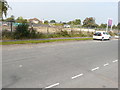
4
Building plot, Jemmett Road
Planning permission has been granted by Ashford Borough Council under application number 17/00381/AS for a “proposed 4-bed dwelling along with double garage & single garage in vacant plot to the side of 25, Jemmett Road”, which is the house on the left.
Image: © John Baker
Taken: 1 Apr 2018
0.13 miles
6
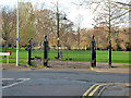
Gates, Victoria Park, Ashford
By J. U. Bugler & Co. Ltd., Ashford.
Image: © Robin Webster
Taken: 4 Dec 2015
0.15 miles
8
19, Jemmett Road
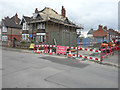
It appears that the house is having its roof tiles relayed, after the renewal of the battens. It stands on corner of Christchurch Road, which, according to the road sign, was due to be closed on Monday 12 March [2018] for up to four weeks.
Image: © John Baker
Taken: 1 Apr 2018
0.16 miles
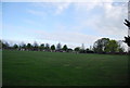
9
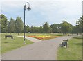
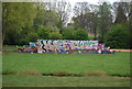
Victoria Park, Ashford
This year's summer bedding.
Image: © John Baker
Taken: 2 Aug 2011
0.16 miles