IMAGES TAKEN NEAR TO
Poundgate, UCKFIELD, TN22 4DE
Introduction
This page details the photographs taken nearby to TN22 4DE by members of the Geograph project.
The Geograph project started in 2005 with the aim of publishing, organising and preserving representative images for every square kilometre of Great Britain, Ireland and the Isle of Man.

There are currently over 7.5m images from over14,400 individuals and you can help contribute to the project by visiting https://www.geograph.org.uk
Image Map
Images are licensed for reuse under creativecommons.org/licenses/by-sa/2.0
Notes
- Clicking on the map will re-center to the selected point.
- The higher the marker number, the further away the image location is from the centre of the postcode.
Image Listing (15 Images Found)
Images are licensed for reuse under creativecommons.org/licenses/by-sa/2.0
Image
Details
Distance
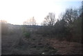
2
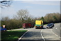
Medieval Pale, Ashdown Forest
This section can be found next to a layby on the A26. There is some conjecture that the area to the south was also once part of the forest as there are records of a gift to neighbouring Newnham Park. This section of the pale runs next to the modern road from the Crow and Gate Inn to the junction with New Road.
Image: © Simon Carey
Taken: 8 May 2022
0.07 miles
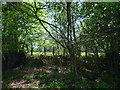
3
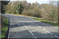
Ashdown Forest
A section of rough grassland to the north of the A26.
Image: © Simon Carey
Taken: 8 May 2022
0.08 miles


9
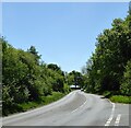
Uckfield Road
The A26 heading south to Uckfield from the junction with New Road. The section between the junction and the curve was the site of Pound Gate, a former medieval entrance to Ashdown Forest.
Image: © Simon Carey
Taken: 8 May 2022
0.17 miles
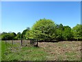
10
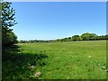
Hop Garden Mead/Nonsuch Meadow
The name of the fields according to Buxted's 1840 tithe map that have been merged to form a larger unit. Hop Garden Mead is in the foreground whilst Nonsuch Meadow is further to the west.
Image: © Simon Carey
Taken: 8 May 2022
0.22 miles