IMAGES TAKEN NEAR TO
London Road, UCKFIELD, TN22 3EP
Introduction
This page details the photographs taken nearby to London Road, TN22 3EP by members of the Geograph project.
The Geograph project started in 2005 with the aim of publishing, organising and preserving representative images for every square kilometre of Great Britain, Ireland and the Isle of Man.

There are currently over 7.5m images from over14,400 individuals and you can help contribute to the project by visiting https://www.geograph.org.uk
Image Map (27 Images)


Getting Data...Please wait
Leaflet Map data © OpenStreetMap
Images are licensed for reuse under creativecommons.org/licenses/by-sa/2.0
Notes
- Clicking on the map will re-center to the selected point.
- The higher the marker number, the further away the image location is from the centre of the postcode.
Image Listing (27 Images Found)
Images are licensed for reuse under creativecommons.org/licenses/by-sa/2.0
Image
Details
Distance
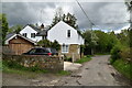
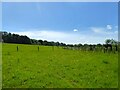
2
Stonebrook, Old Forge Lane, Horney Common
Built sometime in the 19th century and extended over the years. The lane runs along the former pale of Ashdown Forest.
Image: © Simon Carey
Taken: 22 May 2022
0.11 miles
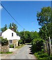
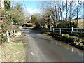
5
Brick Field
The name of the field according to Maresfield's 1840 tithe map bounded by Old Forge Lane to the west that was once the medieval pale of Ashdown Forest.
Image: © Simon Carey
Taken: 22 May 2022
0.13 miles
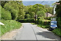
6
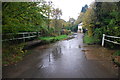
Ford at Horney Common
Shown here after heavy rain this ford is found at Horney Common.
Image: © John Walton
Taken: 9 Nov 2013
0.13 miles
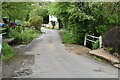
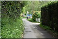
9
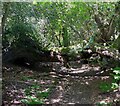
Stanfield Rock
The name of the former field according to Maresfield's 1840 tithe map that is now a small wood. This is the view of Maresfield 74a public footpath heading east to Old Forge Lane
Image: © Simon Carey
Taken: 22 May 2022
0.14 miles
10
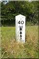
Old Milepost by the A22, Lampool roundabout, Maresfield
Metal plate attached to wooden post by the A22, in parish of MARESFIELD (WEALDEN District), Lampool roundabout, North East edge, on verge beside access road, on East side of road. Bow Bells iron plate, erected by the Malling Street to Wych Cross turnpike trust in the 19th century.
Inscription reads:- : 40 / {Bow & 4 Bells} :
Milestone Society National ID: SX_LL40.
Image: © A Rosevear
Taken: 15 Oct 2012
0.16 miles