IMAGES TAKEN NEAR TO
Meres Lane, MAYFIELD, TN20 6JT
Introduction
This page details the photographs taken nearby to Meres Lane, TN20 6JT by members of the Geograph project.
The Geograph project started in 2005 with the aim of publishing, organising and preserving representative images for every square kilometre of Great Britain, Ireland and the Isle of Man.

There are currently over 7.5m images from over14,400 individuals and you can help contribute to the project by visiting https://www.geograph.org.uk
Image Map
Images are licensed for reuse under creativecommons.org/licenses/by-sa/2.0
Notes
- Clicking on the map will re-center to the selected point.
- The higher the marker number, the further away the image location is from the centre of the postcode.
Image Listing (42 Images Found)
Images are licensed for reuse under creativecommons.org/licenses/by-sa/2.0
Image
Details
Distance
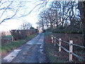
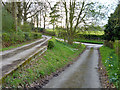
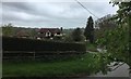
3
Bend on Meres Lane
By the entrance to Allen's Farm.
Image: © Dave Spicer
Taken: 15 Apr 2013
0.04 miles
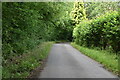
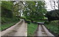
4
Split level drive from Allen's Farm
Nearing Meres Lane, the drive splits into two, with the right hand one looking more original. However the unobtrusive public footpath marker stone is set in the far left hedge corner.
Image: © Robin Webster
Taken: 13 Apr 2012
0.05 miles
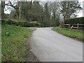
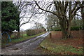
5
Dual Lanes
Allen’s Farm has two driveways side by side but on slightly different levels.
Image: © Chris Thomas-Atkin
Taken: 29 Apr 2018
0.05 miles
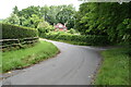
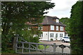
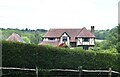
9
Tarragon
The property known as Tarragon viewed from the adjacent grid square.
Image: © Chris Thomas-Atkin
Taken: 29 Apr 2018
0.07 miles