IMAGES TAKEN NEAR TO
Nightingale Close, WESTERHAM, TN16 3LW
Introduction
This page details the photographs taken nearby to Nightingale Close, TN16 3LW by members of the Geograph project.
The Geograph project started in 2005 with the aim of publishing, organising and preserving representative images for every square kilometre of Great Britain, Ireland and the Isle of Man.

There are currently over 7.5m images from over14,400 individuals and you can help contribute to the project by visiting https://www.geograph.org.uk
Image Map
Images are licensed for reuse under creativecommons.org/licenses/by-sa/2.0
Notes
- Clicking on the map will re-center to the selected point.
- The higher the marker number, the further away the image location is from the centre of the postcode.
Image Listing (20 Images Found)
Images are licensed for reuse under creativecommons.org/licenses/by-sa/2.0
Image
Details
Distance

2
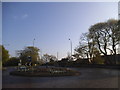
Roundabout at the entrance to Biggin Hill Aerodrome
Image: © David Howard
Taken: 20 Apr 2014
0.07 miles
3
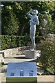
Sculpture in The Strongest Link Garden
New sculpture by John Everiss (unveiled 15 September 2022), a memorial to those who served at Biggin Hill during the Battle of Britain.
Image: © David Martin
Taken: 2 Oct 2022
0.09 miles
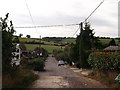
4
Christy Road, Biggin Hill
This road leads up the valleyside from Oaklands Lane.
Jugg Hill wood is in the background.
Image: © David Anstiss
Taken: 9 Oct 2011
0.11 miles
5
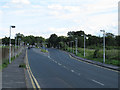
A233 at Biggin Hill
This main road, like most, is mainly unlit through the countryside, but has lights for a short stretch passing the airport entrance.
Image: © Stephen Craven
Taken: 24 Jul 2011
0.13 miles

7
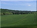
Biggin Hill
The town as seen from the edge of Jewels Wood. Norheads Lane runs through this picture from the left.
Image: © Rose Atkinson
Taken: 6 Jun 2006
0.16 miles
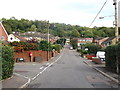
9
Victoria Gardens, Biggin Hill
This road leads down a valley side towards Oaklands Lane.
These houses are furthest north of the village/town (except the new estate near the airport!).
Image: © David Anstiss
Taken: 9 Oct 2011
0.18 miles
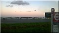
10
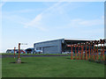
Biggin Hill airport buildings
Viewed from the perimeter fence.
Image: © Stephen Craven
Taken: 24 Jul 2011
0.18 miles