IMAGES TAKEN NEAR TO
Sunningvale Avenue, WESTERHAM, TN16 3BX
Introduction
This page details the photographs taken nearby to Sunningvale Avenue, TN16 3BX by members of the Geograph project.
The Geograph project started in 2005 with the aim of publishing, organising and preserving representative images for every square kilometre of Great Britain, Ireland and the Isle of Man.

There are currently over 7.5m images from over14,400 individuals and you can help contribute to the project by visiting https://www.geograph.org.uk
Image Map (Loading...)


Getting Data...Please wait
Leaflet Map data © OpenStreetMap
Images are licensed for reuse under creativecommons.org/licenses/by-sa/2.0
Notes
- Clicking on the map will re-center to the selected point.
- The higher the marker number, the further away the image location is from the centre of the postcode.
Image Listing (31 Images Found)
Images are licensed for reuse under creativecommons.org/licenses/by-sa/2.0
Image
Details
Distance
1
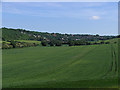
Biggin Hill
The town as seen from the edge of Jewels Wood. Norheads Lane runs through this picture from the left.
Image: © Rose Atkinson
Taken: 6 Jun 2006
0.05 miles
2
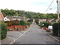
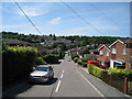
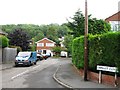
Christy Road, Biggin Hill
This road leads up the valleyside from Oaklands Lane.
Jugg Hill wood is in the background.
Image: © David Anstiss
Taken: 9 Oct 2011
0.06 miles

4
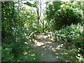
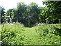
Steps on path at Jugg Hill
The land at Biggin Hill drops away steeply on the west side, with parts being built up and other parts kept as open land. Jugg Hill is on this slope and is almost entirely covered by woodland. This is a path which leads from Main Road opposite Jail Lane down to Sunningvale Close.
Image: © Marathon
Taken: 5 Jul 2017
0.14 miles
6
Biggin Hill Festival of Flight 2016
Rich Goodwin flying a Pitts S2Sa seen from a distance.
Image: © patrick connolly
Taken: 11 Jun 2016
0.15 miles
7
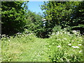
Path at Jugg Hill
The land at Biggin Hill drops away steeply on the west side, with parts being built up and other parts kept as open land. Jugg Hill is on this slope and is almost entirely covered by woodland. This is a path which leads from Main Road opposite Jail Lane down to Sunningvale Close. As it enters the woodland ahead it drops down a series of steps - see http://www.geograph.org.uk/photo/5453898
Image: © Marathon
Taken: 5 Jul 2017
0.16 miles
8
Path at Jugg Hill
The land at Biggin Hill drops away steeply on the west side, with parts being built up and other parts kept as open land. Jugg Hill is on this slope and is almost entirely covered by woodland. This is a path which leads from Sunningvale Close up to Main Road opposite Jail Lane.
Image: © Marathon
Taken: 5 Jul 2017
0.17 miles
9
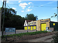
Squires Timber
The business is on the A233 at Biggin Hill. The sign says open Monday to Saturday, but this was a Sunday.
Image: © Stephen Craven
Taken: 24 Jul 2011
0.18 miles