IMAGES TAKEN NEAR TO
Madan Road, WESTERHAM, TN16 1DY
Introduction
This page details the photographs taken nearby to Madan Road, TN16 1DY by members of the Geograph project.
The Geograph project started in 2005 with the aim of publishing, organising and preserving representative images for every square kilometre of Great Britain, Ireland and the Isle of Man.

There are currently over 7.5m images from over14,400 individuals and you can help contribute to the project by visiting https://www.geograph.org.uk
Image Map
Images are licensed for reuse under creativecommons.org/licenses/by-sa/2.0
Notes
- Clicking on the map will re-center to the selected point.
- The higher the marker number, the further away the image location is from the centre of the postcode.
Image Listing (41 Images Found)
Images are licensed for reuse under creativecommons.org/licenses/by-sa/2.0
Image
Details
Distance
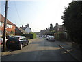
1
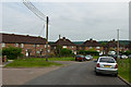
Madan Road
Former council estate on the northern edge of Westerham. Maps suggest that it was developed either side of the Second World War.
Image: © Ian Capper
Taken: 19 Jun 2013
0.02 miles
2
Madan Road
Former council estate on the northern edge of Westerham. Maps suggest that it was developed either side of the Second World War.
Image: © Ian Capper
Taken: 8 Aug 2013
0.04 miles
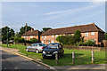
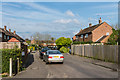
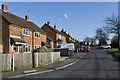
4
Hartley Road
1950s housing on the northern edge of Westerham.
Image: © Ian Capper
Taken: 25 Apr 2013
0.07 miles
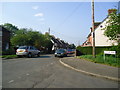
6
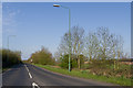
Beggars Lane
Old maps show Beggars Lane to have been a winding country lane running from Force Green Farm, to the north of here, down towards the A25 to the east of Westerham. It has since been diverted further south and widened, and now serves as a east - north bypass for Westerham.
Image: © Ian Capper
Taken: 25 Apr 2013
0.16 miles
7
Hartley Road
1950s housing on the northern edge of Westerham.
Image: © Ian Capper
Taken: 24 Apr 2014
0.17 miles
8
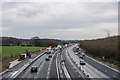
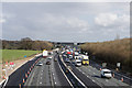
M25 widening
A zoomed in view of the scene in Image, showing the emergency refuge under construction on the left of the photo and the half completed gantry in the background.
For slideshow of photos throughout the works, see http://www.geograph.org.uk/search.php?i=48513555&page=1&displayclass=slide.
Image: © Ian Capper
Taken: 18 Jan 2014
0.17 miles
9
M25 widening
A zoomed in view of the scene in Image, showing the emergency refuge on the left of the photo now completed and the fully installed gantry in the background. Compare Image for a similar view a month or so previously.
For slideshow of photos throughout the works, see http://www.geograph.org.uk/search.php?i=48513555&page=1&displayclass=slide.
Image: © Ian Capper
Taken: 26 Feb 2014
0.17 miles
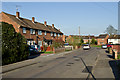
10
London Road
1950s housing on the northern edge of Westerham.
Image: © Ian Capper
Taken: 25 Apr 2013
0.17 miles