IMAGES TAKEN NEAR TO
Cudham Lane North, SEVENOAKS, TN14 7QS
Introduction
This page details the photographs taken nearby to Cudham Lane North, TN14 7QS by members of the Geograph project.
The Geograph project started in 2005 with the aim of publishing, organising and preserving representative images for every square kilometre of Great Britain, Ireland and the Isle of Man.

There are currently over 7.5m images from over14,400 individuals and you can help contribute to the project by visiting https://www.geograph.org.uk
Image Map
Images are licensed for reuse under creativecommons.org/licenses/by-sa/2.0
Notes
- Clicking on the map will re-center to the selected point.
- The higher the marker number, the further away the image location is from the centre of the postcode.
Image Listing (6 Images Found)
Images are licensed for reuse under creativecommons.org/licenses/by-sa/2.0
Image
Details
Distance
1
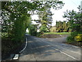
View from Snag Lane
This is the far southern end of Snag Lane, the northern end of which is an ancient trackway and meets the A21 at Green Street Green. Here Snag Lane meets Cudham Lane North which is on the left. The houses are at Hazelwood.
Image: © Marathon
Taken: 10 Jun 2015
0.03 miles
2
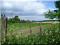
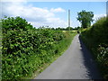
Cudham Lane North
As it passes through Hazelwood.
Image: © Ian Capper
Taken: 1 Apr 2011
0.07 miles
3
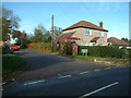
Hazelwood Road, Cudham TN14
At the junction with Cudham Lane North, in the hamlet of Hazelwood.
Image: © Philip Talmage
Taken: 7 Nov 2005
0.10 miles
4
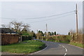
Snag Lane
This is the far southern end of Snag Lane, the northern end of which is an ancient trackway and meets the A21 at Green Street Green. Just behind where I am standing, Snag Lane meets Cudham Lane North.
Image: © Marathon
Taken: 10 Jun 2015
0.12 miles
5
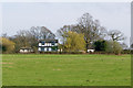
Snag Lane Farm
A house on Snag Lane, viewed from Cudham Lane North.
Image: © Ian Capper
Taken: 1 Apr 2011
0.14 miles