IMAGES TAKEN NEAR TO
Woodlands View, SEVENOAKS, TN14 7AR
Introduction
This page details the photographs taken nearby to Woodlands View, TN14 7AR by members of the Geograph project.
The Geograph project started in 2005 with the aim of publishing, organising and preserving representative images for every square kilometre of Great Britain, Ireland and the Isle of Man.

There are currently over 7.5m images from over14,400 individuals and you can help contribute to the project by visiting https://www.geograph.org.uk
Image Map
Images are licensed for reuse under creativecommons.org/licenses/by-sa/2.0
Notes
- Clicking on the map will re-center to the selected point.
- The higher the marker number, the further away the image location is from the centre of the postcode.
Image Listing (34 Images Found)
Images are licensed for reuse under creativecommons.org/licenses/by-sa/2.0
Image
Details
Distance
1
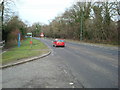
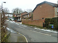
Orpington By-Pass, Badgers Mount, Kent
Image: © Stacey Harris
Taken: 24 Jan 2009
0.06 miles
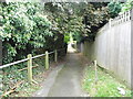
2
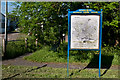
Footpath and map
Shoreham Parish Council have kindly provided a map at Badgers Mount. On the left is a footpath to Old London Road - see Image for close up of sign visible in the background next to the map.
Image: © Ian Capper
Taken: 14 Jun 2012
0.06 miles
3
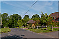
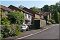
Badgers Road
Recent housing in Badgers Road
Image: © Ian Capper
Taken: 14 Jun 2012
0.06 miles
4
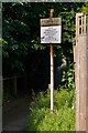
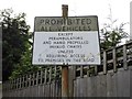
Modified sign
Close up of sign by footpath in Image There must be some legal definition of vehicles, leading to the requirement for such precise exceptions.
Image: © Ian Capper
Taken: 14 Jun 2012
0.07 miles
5
Pre-Worboys sign on path by London Road
This is a detail of a sign already posted to this square, and as expected there was an identical one at the other end although covered by a tree. The reflective lettering above has been covered below by a transfer updating the conditions, but still pre-1964 and in very good condition for its age. The backing plate is unaffected, and the red circle which would have been on top has either been removed or fallen off.
Image: © David Howard
Taken: 30 Sep 2012
0.07 miles
6
Badgers Rise
Recent housing off London Road
Image: © Ian Capper
Taken: 14 Jun 2012
0.07 miles
7
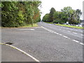
The A224 at the corner of Badger's Road
Image: © David Howard
Taken: 30 Sep 2012
0.07 miles
8
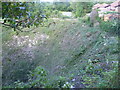
Looking across the northern entrance to Polhill Tunnel
The South Eastern Railway (SER) opened their "cut off" line through Orpington and Sevenoaks to Tonbridge on 2nd March 1868. This shortened its route from London to Dover which previously went via Redhill. From 1994 until 2003 Eurostars ran along this line to and from the Channel Tunnel.
Travelling between Chelsfield and Tonbridge there are three long tunnels. The first one is Knockholt Tunnel at 800 yards after which comes Knockholt station. Then comes Polhill Tunnel which was built between 1864 and 1868 and is 1 mile 849yd long. The two tunnels either side of Knockholt station have very deep cuttings through the chalk as seen in this view across the northern entrance to Polhill Tunnel, seen from Old London Road. The entrance to the tunnel is just below the left hand side of the photograph. The houses on the right above the tunnel are in Badgers Rise.
After Sevenoaks comes Sevenoaks Tunnel which is just under two miles long - see http://www.geograph.org.uk/photo/3511614
Image: © Marathon
Taken: 27 Aug 2013
0.07 miles
9
Badgers Rise, Badgers Mount
A developer's private joke?
Image: © Robin Webster
Taken: 14 Feb 2012
0.08 miles
10
Path between The A224 and London Road
Image: © David Howard
Taken: 30 Sep 2012
0.08 miles