IMAGES TAKEN NEAR TO
Goathurst Common, SEVENOAKS, TN14 6DB
Introduction
This page details the photographs taken nearby to Goathurst Common, TN14 6DB by members of the Geograph project.
The Geograph project started in 2005 with the aim of publishing, organising and preserving representative images for every square kilometre of Great Britain, Ireland and the Isle of Man.

There are currently over 7.5m images from over14,400 individuals and you can help contribute to the project by visiting https://www.geograph.org.uk
Image Map
Images are licensed for reuse under creativecommons.org/licenses/by-sa/2.0
Notes
- Clicking on the map will re-center to the selected point.
- The higher the marker number, the further away the image location is from the centre of the postcode.
Image Listing (9 Images Found)
Images are licensed for reuse under creativecommons.org/licenses/by-sa/2.0
Image
Details
Distance
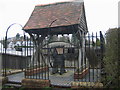
3
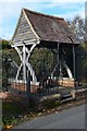
Well at Goathurst Common
Sunk in 1901, restored in 1994 and 190 feet deep.
Image: © David Martin
Taken: 29 Oct 2018
0.11 miles
5
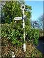
Direction Sign ? Signpost at Goathurst Common in Sundridge and Ide Hill parish
Located at Goathurst Common, on the north side of a crossroads on the B2042 Wheatsheaf Hill, in Sundridge and Ide Hill parish. 3 worboys arms and annulus finial.
Milestone Society National ID: KE_TQ4952
Image: © John V Nicholls
Taken: 30 Dec 2012
0.13 miles
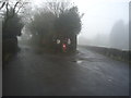
7
Goathurst Common Well
Prior to the sinking of the well in 1901, villagers used water from rainwater storage tanks. When these ran dry, villagers had to walk down a steep hill to the springs south of Stubbs Woods, to collect their water. Piped water was brought to the area during the 1920s.
Image: © Nikki Mahadevan
Taken: 14 Apr 2006
0.15 miles
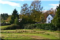
9
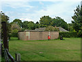
Brick building, Goathurst Common
In the corner of the recreation ground, this structure seems to pre-date the use of this field for recreation. It has bricked-up openings on this side and has an air of being a WWII building - an air-raid shelter?
Image: © Robin Webster
Taken: 19 Aug 2011
0.21 miles