IMAGES TAKEN NEAR TO
Roundel Way, TONBRIDGE, TN12 9TW
Introduction
This page details the photographs taken nearby to Roundel Way, TN12 9TW by members of the Geograph project.
The Geograph project started in 2005 with the aim of publishing, organising and preserving representative images for every square kilometre of Great Britain, Ireland and the Isle of Man.

There are currently over 7.5m images from over14,400 individuals and you can help contribute to the project by visiting https://www.geograph.org.uk
Image Map
Images are licensed for reuse under creativecommons.org/licenses/by-sa/2.0
Notes
- Clicking on the map will re-center to the selected point.
- The higher the marker number, the further away the image location is from the centre of the postcode.
Image Listing (229 Images Found)
Images are licensed for reuse under creativecommons.org/licenses/by-sa/2.0
Image
Details
Distance
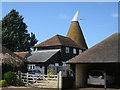
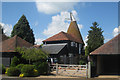
1
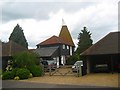
Oast House, Sutton Forge, Marden, Kent
Image: © Oast House Archive
Taken: 20 May 2007
0.01 miles
2
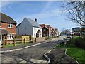
New housing estate, Napoleon Drive
Currently under construction by Millwood Homes.
Image: © Oast House Archive
Taken: 17 Apr 2018
0.07 miles
3
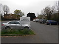
Free Car Park, Marden
Only a few minutes walk from the railway station. The catch is that parking is forbidden between 7.15 and 8.15 am, thus causing minimal inconvenience to shoppers and library users whilst making it impossible to be in London before 9.30am and still use the car park legally.
Image: © Danny P Robinson
Taken: 30 Mar 2014
0.07 miles
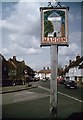
4
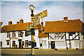
Marden
Village signpost with The Unicorn pub and half-timbered house behind, Marden High Street.
Image: © Colin Smith
Taken: Unknown
0.07 miles
5
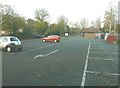
Marden carpark
Situated at the back of the library. The building beyond the recycling bins is a public convenience.
Image: © John Baker
Taken: 20 Nov 2011
0.07 miles
7
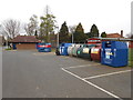
Public Toilets and Recycling Point, Marden
In the Marden Village public car park, behind the library.
Image: © Danny P Robinson
Taken: 30 Mar 2014
0.08 miles
9
Marden Village Sign
On junction of Albion Road (on left) and Howland Road (on right). It shows the village stocks outside the church, flanked by the village pump and a fruit tree, with a garland of hops on the bine across the top.
Image: © David Anstiss
Taken: 5 Apr 2009
0.09 miles