IMAGES TAKEN NEAR TO
Longend Lane, TONBRIDGE, TN12 9SE
Introduction
This page details the photographs taken nearby to Longend Lane, TN12 9SE by members of the Geograph project.
The Geograph project started in 2005 with the aim of publishing, organising and preserving representative images for every square kilometre of Great Britain, Ireland and the Isle of Man.

There are currently over 7.5m images from over14,400 individuals and you can help contribute to the project by visiting https://www.geograph.org.uk
Image Map
Images are licensed for reuse under creativecommons.org/licenses/by-sa/2.0
Notes
- Clicking on the map will re-center to the selected point.
- The higher the marker number, the further away the image location is from the centre of the postcode.
Image Listing (25 Images Found)
Images are licensed for reuse under creativecommons.org/licenses/by-sa/2.0
Image
Details
Distance
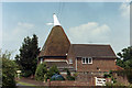
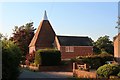
3
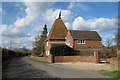
Longends Oast, Longend Lane, Marden, Kent
Image: © Oast House Archive
Taken: 3 Mar 2008
0.12 miles

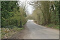
7
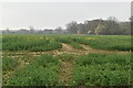
Footpath crosses Long Ends Lane
Path from Pattenden Lane, Marden, leads through Brook Farm then across this lane and fields to B2162 Maidstone Road, Collier Street.
Image: © David Anstiss
Taken: 1 Apr 2009
0.18 miles
10
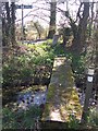
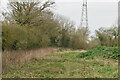
Footbridge near Long Ends Lane
Footpath from B2162 Maidstone Road, Collier Street leads through fields to this sleeper bridge near the lane. Bridge goes over stream near woodland pond.
Image: © David Anstiss
Taken: 1 Apr 2009
0.19 miles