IMAGES TAKEN NEAR TO
Howland Road, TONBRIDGE, TN12 9LE
Introduction
This page details the photographs taken nearby to Howland Road, TN12 9LE by members of the Geograph project.
The Geograph project started in 2005 with the aim of publishing, organising and preserving representative images for every square kilometre of Great Britain, Ireland and the Isle of Man.

There are currently over 7.5m images from over14,400 individuals and you can help contribute to the project by visiting https://www.geograph.org.uk
Image Map
Images are licensed for reuse under creativecommons.org/licenses/by-sa/2.0
Notes
- Clicking on the map will re-center to the selected point.
- The higher the marker number, the further away the image location is from the centre of the postcode.
Image Listing (58 Images Found)
Images are licensed for reuse under creativecommons.org/licenses/by-sa/2.0
Image
Details
Distance
1

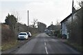
Houses on Howland Road
Viewed from railway line, approaching Marden Station
Image: © Clint Mann
Taken: 10 Aug 2016
0.01 miles

4

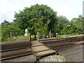
Railway to Staplehurst
Railway leads onto Staplehurst and then onto Ashford from Marden / Paddock Wood. As seen from level crossing on footpath from Howland Road to Battle Lane.
Image: © David Anstiss
Taken: 5 Apr 2009
0.02 miles
5
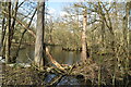
Level crossing near Howland Road
Footpath from Howland Road, leads over the railway to a reservoir/ fishing lake near Bridgehurst Wood, then leads onto Battle Lane, St Ann's Green.
Image: © David Anstiss
Taken: 5 Apr 2009
0.02 miles
6
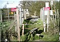
Foot crossing near Howland Road
The South Eastern Railway opened its line from Redhill to Ashford and on to Dover on 31st August 1842. Between Redhill and Ashford it is almost ruler straight. Eurostars ran along this line between 1994 and 2003 prior to the opening of High Speed One to St Pancras International.
The next station to the right is Staplehurst and to the left is Marden. The view from the crossing can be seen at https://www.geograph.org.uk/photo/7178665
Image: © Marathon
Taken: 21 May 2022
0.03 miles

8
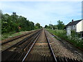
View from a foot crossing alongside Howland Road
The South Eastern Railway opened its line from Redhill to Ashford and on to Dover on 31st August 1842. Between Redhill and Ashford it is almost ruler straight. Eurostars ran along this line between 1994 and 2003 prior to the opening of High Speed One to St Pancras International.
The next station in this direction is Staplehurst. For a view of the crossing see https://www.geograph.org.uk/photo/7184798
Image: © Marathon
Taken: 21 May 2022
0.03 miles
9
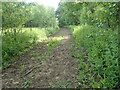
Footpath to Howland Road
The foot crossing over the railway is just ahead - see https://www.geograph.org.uk/photo/7184798
Image: © Marathon
Taken: 21 May 2022
0.05 miles