IMAGES TAKEN NEAR TO
Maer Lane Industrial Estate, Llewellyn Roberts Way, MARKET DRAYTON, TF9 1QS
Introduction
This page details the photographs taken nearby to Maer Lane Industrial Estate, Llewellyn Roberts Way, TF9 1QS by members of the Geograph project.
The Geograph project started in 2005 with the aim of publishing, organising and preserving representative images for every square kilometre of Great Britain, Ireland and the Isle of Man.

There are currently over 7.5m images from over14,400 individuals and you can help contribute to the project by visiting https://www.geograph.org.uk
Image Map
Images are licensed for reuse under creativecommons.org/licenses/by-sa/2.0
Notes
- Clicking on the map will re-center to the selected point.
- The higher the marker number, the further away the image location is from the centre of the postcode.
Image Listing (30 Images Found)
Images are licensed for reuse under creativecommons.org/licenses/by-sa/2.0
Image
Details
Distance
1
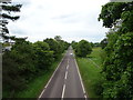
A53, Market Drayton
Looking west from the bridge on Maer Lane.
Image: © JThomas
Taken: 1 Jun 2019
0.07 miles
2
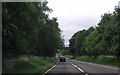
Maer lane crossing A53
North of Market Drayton
Image: © John Firth
Taken: 15 Jun 2013
0.09 miles
3
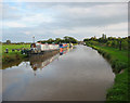
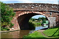
View south east from Victoria Bridge
Autumnal evening light on the Shropshire Union Canal. The bridge in the distance is the A53 on the outskirts of Market Drayton
Image: © Espresso Addict
Taken: 8 Oct 2006
0.22 miles
4
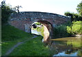
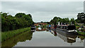
Victoria Bridge No 65
Carrying Maer Lane across the Shropshire Union Canal, on the northern edge of Market Drayton.
Image: © Mat Fascione
Taken: 5 Jul 2019
0.23 miles
5
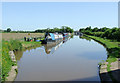
Shropshire Union Canal near Market Drayton, Shropshire
This canal has many straight stretches, as here where it approaches Market Drayton, seen from below Victoria Bridge.
When the early canals were being pioneered in the 18th century by engineers such as James Brindley, the routes taken were usually level, contour hugging and (as a result) meandering. This was done to avoid the necessity for building locks and embankments and digging cuttings where-ever possible. The mileage for working boats to cover could be very considerable.
By the time railways were in the ascendency towards the middle of the 19th century, the time boats took for their journeys needed to be cut as much as possible. Early canals such as the Oxford Canal were straightened (and consequently their mileage shortened) considerably by the construction of cuttings and embankments in the 1820s.
Here, the Birmingham and Liverpool Junction Canal (now called the Shropshire Union Canal) was not built until the 1830s. Thomas Telford the engineer took the shortest possible route that technology of the time could manage. His flights of locks, huge embankments and long cuttings are a characteristic of the canal, and caused (and still cause) problems with breaches and blockages. However, by 1835 the canal was opened fully.
Image: © Roger D Kidd
Taken: 24 May 2009
0.23 miles
6
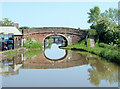
Victoria Bridge near Market Drayton, Shropshire
Bridge No 65 on the Shropshire Union Canal (opened in 1835, engineered by Thomas Telford). Victoria Wharf on the left was for many years used for loading and unloading coal, but Orwell's is now a boatyard (coal still available in smaller bags).
Image: © Roger D Kidd
Taken: 24 May 2009
0.23 miles
8
Orwells Boatyard at Market Drayton
Next to Victoria Bridge No 65, on the northern edge of the town.
Image: © Mat Fascione
Taken: 5 Jul 2019
0.24 miles
9
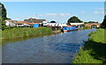
Moorings north of Market Drayton, Shropshire
These private long-term moorings north of Market Drayton are by Victoria Bridge, No 65. Victoria Wharf is north of the bridge.
Image: © Roger Kidd
Taken: 5 Jun 2018
0.24 miles
10
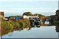
Canal at Victoria Wharf near Market Drayton, Shropshire
Orwell's Boatyard ahead used to be just a coal and wood merchant. Victoria Bridge is No 65 across the Shropshire Union Canal, and carries Maer Lane.
Image: © Roger Kidd
Taken: 21 Oct 2012
0.24 miles