Shropshire Union Canal near Market Drayton, Shropshire
Introduction
The photograph on this page of Shropshire Union Canal near Market Drayton, Shropshire by Roger D Kidd as part of the Geograph project.
The Geograph project started in 2005 with the aim of publishing, organising and preserving representative images for every square kilometre of Great Britain, Ireland and the Isle of Man.

There are currently over 7.5m images from over 14,400 individuals and you can help contribute to the project by visiting https://www.geograph.org.uk
Shropshire Union Canal near Market Drayton, Shropshire
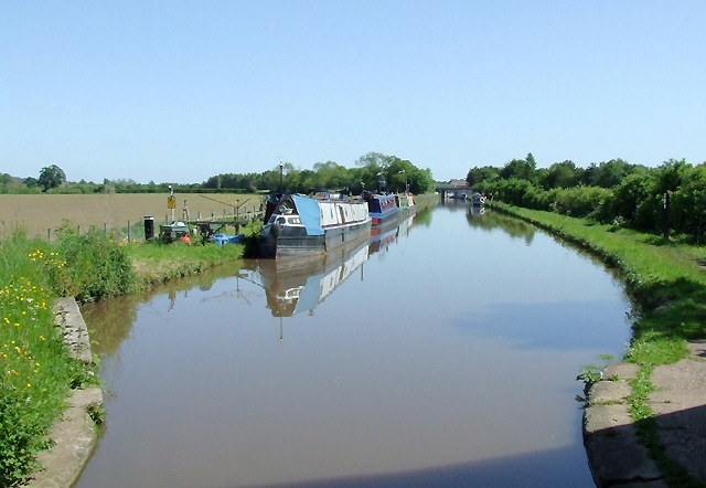
Image: © Roger D Kidd Taken: 24 May 2009
This canal has many straight stretches, as here where it approaches Market Drayton, seen from below Victoria Bridge. When the early canals were being pioneered in the 18th century by engineers such as James Brindley, the routes taken were usually level, contour hugging and (as a result) meandering. This was done to avoid the necessity for building locks and embankments and digging cuttings where-ever possible. The mileage for working boats to cover could be very considerable. By the time railways were in the ascendency towards the middle of the 19th century, the time boats took for their journeys needed to be cut as much as possible. Early canals such as the Oxford Canal were straightened (and consequently their mileage shortened) considerably by the construction of cuttings and embankments in the 1820s. Here, the Birmingham and Liverpool Junction Canal (now called the Shropshire Union Canal) was not built until the 1830s. Thomas Telford the engineer took the shortest possible route that technology of the time could manage. His flights of locks, huge embankments and long cuttings are a characteristic of the canal, and caused (and still cause) problems with breaches and blockages. However, by 1835 the canal was opened fully.
Images are licensed for reuse under creativecommons.org/licenses/by-sa/2.0
Image Location
Latitude
52.91308
Longitude
-2.478494