IMAGES TAKEN NEAR TO
Hillside, TELFORD, TF8 7QP
Introduction
This page details the photographs taken nearby to Hillside, TF8 7QP by members of the Geograph project.
The Geograph project started in 2005 with the aim of publishing, organising and preserving representative images for every square kilometre of Great Britain, Ireland and the Isle of Man.

There are currently over 7.5m images from over14,400 individuals and you can help contribute to the project by visiting https://www.geograph.org.uk
Image Map
Images are licensed for reuse under creativecommons.org/licenses/by-sa/2.0
Notes
- Clicking on the map will re-center to the selected point.
- The higher the marker number, the further away the image location is from the centre of the postcode.
Image Listing (660 Images Found)
Images are licensed for reuse under creativecommons.org/licenses/by-sa/2.0
Image
Details
Distance
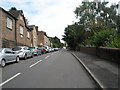
1
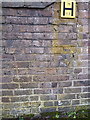
OS benchmark - Ironbridge, Hodgebower
An OS cutmark on a wall on the south side of Hodgebower; originally levelled at 106.119m above Ordnance Datum Newlyn.
Image: © Richard Law
Taken: 1 Mar 2014
0.03 miles
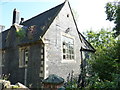
2
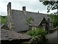
Former Church of England School (Ironbridge)
Built in 1859, this building used to house a Church of England school at Ironbridge in its day, but it is now a private house by today.
Image: © Fabian Musto
Taken: 30 May 2019
0.04 miles
3
Ironbridge.
Ironbridge in Shropshire. A fascinating place to visit, the birthplace of industry.
Image: © Paul Russon
Taken: Unknown
0.04 miles
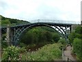
4
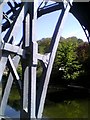
Detail of the Iron Bridge
Note the wood working type joints on the world's first iron bridge. See for historical details http://www.ironbridge.org.uk/
Image: © David Bagshaw
Taken: 15 May 2005
0.04 miles
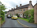
5
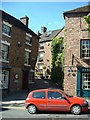
Severn Bank
This steep and narrow street leads up towards the church from the River Severn.
Image: © John M
Taken: 11 May 2002
0.04 miles
6
Former Church of England School (Ironbridge)
The over the top patterns on this chimney belongs to the former Church of England school at Ironbridge, and this view is from St. Luke's Road.
Image: © Fabian Musto
Taken: 30 May 2019
0.04 miles
7
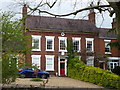
Edgmont House, Hodgebower, Ironbridge
A Grade II listed building http://www.britishlistedbuildings.co.uk/101374899-belmontedgmont-the-gorge#.WRvthPkrKM8 dated 1758, now known as Edgmont but previously called Belmont.
Image: © Richard Law
Taken: 17 Apr 2017
0.05 miles
8
The former CofE school, St Luke's Road, Ironbridge
Built in the late 1850s, and originally constructed for use as a Church of England School for the town. It appears to be unused at present, but has a Grade II listing https://britishlistedbuildings.co.uk/101038661-church-of-england-school-the-gorge#.XasaIehKjIU & https://historicengland.org.uk/listing/the-list/list-entry/1038661 which was granted in 1974.
Image: © Richard Law
Taken: 26 Aug 2019
0.05 miles
9
The Brockholes cottages, Ironbridge
Described in their collective 1974 Grade II listing https://britishlistedbuildings.co.uk/101207373-the-brockholes-the-gorge#.X20dAGhKjIU & https://historicengland.org.uk/listing/the-list/list-entry/1207373 as a "plain early-mid C19 cottage range". The small-paned iron casements mentioned in the listing have apparently gone now, replaced by newer casements and sashes, but the essential character of the row remains.
Image: © Richard Law
Taken: 6 Aug 2020
0.06 miles