IMAGES TAKEN NEAR TO
Chapel Road, TELFORD, TF8 7LU
Introduction
This page details the photographs taken nearby to Chapel Road, TF8 7LU by members of the Geograph project.
The Geograph project started in 2005 with the aim of publishing, organising and preserving representative images for every square kilometre of Great Britain, Ireland and the Isle of Man.

There are currently over 7.5m images from over14,400 individuals and you can help contribute to the project by visiting https://www.geograph.org.uk
Image Map
Images are licensed for reuse under creativecommons.org/licenses/by-sa/2.0
Notes
- Clicking on the map will re-center to the selected point.
- The higher the marker number, the further away the image location is from the centre of the postcode.
Image Listing (145 Images Found)
Images are licensed for reuse under creativecommons.org/licenses/by-sa/2.0
Image
Details
Distance
1
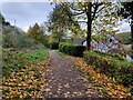
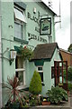
The Severn Way at Coalford
The building on the right is the Black Swan public house.
The Severn Way is a long-distance footpath which follows the course of the River Severn, it is 224 miles (360 km) long.
Image: © Mat Fascione
Taken: 6 Nov 2021
0.02 miles
3
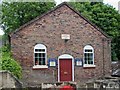
Coalford Wesleyan Chapel 1824
The building is now host to the Jackfield Brass Band.
Image: © Mike White
Taken: 6 Jul 2008
0.04 miles
4
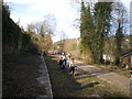
All that remains of Jackfield Station
The tatty remains of the platform of Jackfield Station, sitting sadly beside the old railway line.
Image: © Richard Law
Taken: 21 Mar 2010
0.04 miles
5
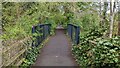
Severn Valley Way cycle track / path
Small bridge on the cycle path
Image: © TCExplorer
Taken: 29 Apr 2023
0.06 miles
6
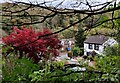
Houses at Coalford
Viewed from the Severn Way.
Image: © Mat Fascione
Taken: 6 Nov 2021
0.06 miles
7
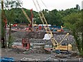
Lloyds Stabilisation 2008
Lloyds Stabilisation project, due for completion Autumn 2008. 370 tubular steel piles 10 - 20 metres long are being driven into the bank on both sides of the River Severn, to curb the natural tendency of the sides of the Severn Gorge to slid into the water. The works are duplicated on both sides of the river, with 90-ton cranes and 100-ton pile-drivers. Sabrina looks rather subdued--at the moment...
Image: © Mike White
Taken: 6 Jul 2008
0.07 miles
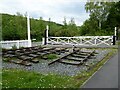
8
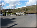
Jackfield Sidings crossing gates
One of the pair of identical wooden gates at the point where Lloyds Head crosses the former line between Kidderminster and Shrewsbury. They are quite possibly original and thus date back to 1862 or thereabouts; Grade II listed https://www.britishlistedbuildings.co.uk/101374371-railway-level-crossing-gates-north-north-west-of-calcutts-house-the-gorge#.WtRGefnwaM8 in 1983.
Image: © Richard Law
Taken: 25 Mar 2018
0.07 miles
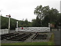
10
Jackfield Sidings
The Jackfield Sidings and a surviving piece of railway track on the former Kidderminster to Shrewsbury railway. Further south the line between Kidderminster and Bridgnorth is the heritage Severn Valley Railway. North of Bridgnorth the track was lifted many years ago and today it is a cycleway.
Image: © Philip Halling
Taken: 2 Jun 2021
0.08 miles