
IMAGES TAKEN NEAR TO
The Lloyds, TELFORD, TF8 7HL
Introduction
This page details the photographs taken nearby to The Lloyds, TF8 7HL by members of the Geograph project.
The Geograph project started in 2005 with the aim of publishing, organising and preserving representative images for every square kilometre of Great Britain, Ireland and the Isle of Man.

There are currently over 7.5m images from over14,400 individuals and you can help contribute to the project by visiting https://www.geograph.org.uk
Image Map
Images are licensed for reuse under creativecommons.org/licenses/by-sa/2.0
Notes
- Clicking on the map will re-center to the selected point.
- The higher the marker number, the further away the image location is from the centre of the postcode.
Image Listing (134 Images Found)
Images are licensed for reuse under creativecommons.org/licenses/by-sa/2.0
Image
Details
Distance
1
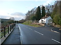
The Lloyds House near Ironbridge
A very crooked old house that at first sight makes you check your eyesight. It is as if it has been jerry built out of cake icing and has melted in the winter sunshine. Or out of MDF and been soaking up rainwater. Or as a film set by drunken set-builders. Or by over keen residents in the early 20th century on land that is liable to subsidence or landslips. Other than that it looks exceedingly well kept.
Do the bedrooms have sloping beds? Or hammocks like a ship of the line in Nelson's day?
I am suddenly, after an interval of around 43 years, reminded of the nursery rhyme;
There was a crooked man, and he walked a crooked mile.
He found a crooked sixpence against a crooked stile.
He bought a crooked cat, which caught a crooked mouse,
And they all lived together in a little crooked house.
This must be that house obviously.
Image: © Jeremy Bolwell
Taken: 3 Jan 2012
0.01 miles
2

The flooded Half Moon Inn
The River Severn encroaching on the pub... again!
Image: © Andrew Abbott
Taken: 26 Feb 2020
0.07 miles
3

The Half Moon pub at Jackfield
Surprisingly, this popular pub doesn't seem to have been photographed for the Geograph site up to now, apart from an aerial shot of it experiencing somewhat strained circumstances Image taken in the winter 3 years ago.
Image: © Richard Law
Taken: 19 Aug 2023
0.08 miles
4
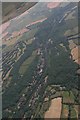
River Severn between Coalport and Jackfield: aerial 2018
Image: © Chris
Taken: 30 Jun 2018
0.08 miles
5
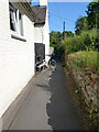
Knockturn Alley
A narrow pathway behind the Half Moon pub and a row of cottages, presumably once housing workers at the nearby tile works.
Image: © Richard Law
Taken: 4 Jun 2023
0.09 miles
6

Cycle path on the Jackfield landslip
The stabilisation scheme started in 2014 and resulted in the construction of a new section of road and rebuilding of this path, itself part of the former Severn Valley Railway. The metal poles just visible to the right are rows of reinforced steel piles acting as buried walls holding up the hillside. The mine workings beneath had previously been filled with grout via a grid network of boreholes.
Image: © TCExplorer
Taken: 29 Apr 2023
0.12 miles
7
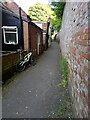
Knockturn Alley
Another view of the narrow pathway behind a row of cottages in Jackfield
Image: © Richard Law
Taken: 4 Jun 2023
0.13 miles
8

Lloyds Stabilisation 19??
Just downstream from the 2008 Lloyds Stabilisation can be seen the remains of previous riverbank stabilisation projects. The concrete wall on the far bank is collapsing outwards and the cast-iron caissons on the near bank have fallen into the river.
Image: © Mike White
Taken: 6 Jul 2008
0.13 miles
9
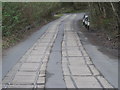
The lane to Jackfield
The wooden boards are obviously there for a reason, but what is that reason?
Image: © Row17
Taken: 13 Mar 2008
0.13 miles
