IMAGES TAKEN NEAR TO
Mimosa Close, TELFORD, TF7 4DU
Introduction
This page details the photographs taken nearby to Mimosa Close, TF7 4DU by members of the Geograph project.
The Geograph project started in 2005 with the aim of publishing, organising and preserving representative images for every square kilometre of Great Britain, Ireland and the Isle of Man.

There are currently over 7.5m images from over14,400 individuals and you can help contribute to the project by visiting https://www.geograph.org.uk
Image Map
Images are licensed for reuse under creativecommons.org/licenses/by-sa/2.0
Notes
- Clicking on the map will re-center to the selected point.
- The higher the marker number, the further away the image location is from the centre of the postcode.
Image Listing (369 Images Found)
Images are licensed for reuse under creativecommons.org/licenses/by-sa/2.0
Image
Details
Distance
1
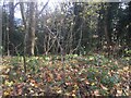
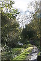
Maple leaves, Sutton Hill
A woodland summit on former agricultural land.
Image: © Richard Webb
Taken: 8 Dec 2021
0.07 miles
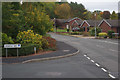
2
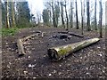
Sutton Hill
Parked on Reynards Coppice then found footpath through the woods to the summit.
Name: Sutton Hill
Hill number: 17217
Height: 138m / 453ft
Parent (Ma/M): 2843 The Wrekin
Section: 38A: Shropshire
County/UA: Telford and Wrekin (UA)
Class: Tump (100-199m)
Grid ref: SJ 69676 03306
Summit feature: no feature: ground in trees between houses
Drop: 39m
Col: 99m SJ706047
Image: © Rude Health
Taken: 25 Mar 2015
0.07 miles
3
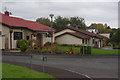
Punta Verde Drive, Sutton Hill
At the south end of Great Hay Drive is a small estate of highly unusual Spanish-style houses built by Tarmac in 1989. The name Punta Verde Drive emphasises the theme.
Image: © Stephen McKay
Taken: 10 Oct 2015
0.08 miles
4
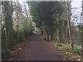
Path, Sutton Hill
A strip of woodland amongst the houses. Pre Telford mapping shows that this was once farmland.
Image: © Richard Webb
Taken: 8 Dec 2021
0.11 miles
5
Great Hay Drive, Sutton Hill
Seen at the junction with Verbena Way with Carnoustie Drive leading off to the right.
Image: © Stephen McKay
Taken: 10 Oct 2015
0.11 miles
6
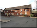
Late 18th century barn at The Telford Hotel & Golf Resort
Fairly recently known as the Great Hay Golf Course, but now part of a more extensive hotel and leisure facility. The barn dates from 1775, and was (probably still is) essentially the golf club shop and changing rooms at the time of its Grade II listing https://britishlistedbuildings.co.uk/101054165-golf-club-shop-and-changing-rooms-north-of-hay-house-farmhouse-madeley#.XiS0MWj7TIU & https://historicengland.org.uk/listing/the-list/list-entry/1054165 in 1983.
Image: © Richard Law
Taken: 5 Jan 2020
0.15 miles
7
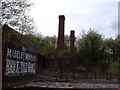
Brick and tile works
The remains of the Madeley Wood Co brick and tile works in Blist Hill museum.
Image: © Roger Dean
Taken: 3 May 2006
0.16 miles
9
Blists Hill - canal
This is the tub boat canal within Blists Hill Victorian Town that leads to the top of the Hay Inclined Plane. On this occasion access beyond here was not possible as a fireworks display had been set up beyond this point.
Image: © Chris Allen
Taken: 3 Nov 2012
0.17 miles
10
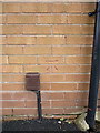
OS benchmark - Sutton Hill, 9 Smallwood
An OS cutmark on the rear of no 9 Smallwood (facing onto Sutton Way); originally levelled at 129.766m above Ordnance Datum Newlyn.
Image: © Richard Law
Taken: 15 Nov 2015
0.17 miles