IMAGES TAKEN NEAR TO
Isombridge, TELFORD, TF6 6NF
Introduction
This page details the photographs taken nearby to TF6 6NF by members of the Geograph project.
The Geograph project started in 2005 with the aim of publishing, organising and preserving representative images for every square kilometre of Great Britain, Ireland and the Isle of Man.

There are currently over 7.5m images from over14,400 individuals and you can help contribute to the project by visiting https://www.geograph.org.uk
Image Map (Loading...)


Getting Data...Please wait
Leaflet Map data © OpenStreetMap
Images are licensed for reuse under creativecommons.org/licenses/by-sa/2.0
Notes
- Clicking on the map will re-center to the selected point.
- The higher the marker number, the further away the image location is from the centre of the postcode.
Image Listing (13 Images Found)
Images are licensed for reuse under creativecommons.org/licenses/by-sa/2.0
Image
Details
Distance
1
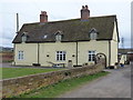
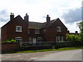
Isombridge Cottages
Late 17th century timber-framed cottages (which have been roughcast rendered in the meantime, clearly) which were Grade II listed https://www.britishlistedbuildings.co.uk/101033300-isombridge-cottages-rodington#.Wr-dXdQrLGg in 1983.
Image: © Richard Law
Taken: 23 Mar 2018
0.01 miles
2
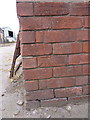
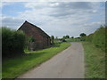
OS benchmark - Isombridge Farm
An OS cutmark on the wall of one of the barns at Isombridge Farm. It was last levelled in 1966 at 50.774m above Ordnance Datum Newlyn, and appears to replace an older mark (shown on maps around the turn of the 19th century) located on the farm wall more or less in front of Image
Image: © Richard Law
Taken: 23 Mar 2018
0.04 miles
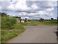
9
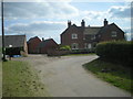
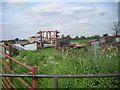
Abandoned kit at the lane junction
The inside of the corner appears to be used as a dumping ground for spare or disused farm equipment.
Image: © Richard Law
Taken: 25 Jan 2015
0.14 miles