IMAGES TAKEN NEAR TO
Sleap, TELFORD, TF6 6HR
Introduction
This page details the photographs taken nearby to TF6 6HR by members of the Geograph project.
The Geograph project started in 2005 with the aim of publishing, organising and preserving representative images for every square kilometre of Great Britain, Ireland and the Isle of Man.

There are currently over 7.5m images from over14,400 individuals and you can help contribute to the project by visiting https://www.geograph.org.uk
Image Map (Loading...)


Getting Data...Please wait
Leaflet Map data © OpenStreetMap
Images are licensed for reuse under creativecommons.org/licenses/by-sa/2.0
Notes
- Clicking on the map will re-center to the selected point.
- The higher the marker number, the further away the image location is from the centre of the postcode.
Image Listing (6 Images Found)
Images are licensed for reuse under creativecommons.org/licenses/by-sa/2.0
Image
Details
Distance
2
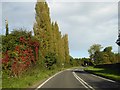
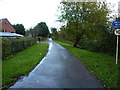
Autumn colour by the A442 south of Crudgington
Just after the sign for the village, and just before the speed limit through the village
Image: © David Smith
Taken: 30 Sep 2016
0.10 miles
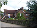
4
Private road in Crudgington
The current map shows this as a 'yellow' road, but if the signage is to be believed, it appears to have been disowned by the Highways Authority and passed to the residents of southern Crudgington as a private road. It's drivable, but has several speed bumps across it.
Image: © Richard Law
Taken: 5 Nov 2017
0.21 miles
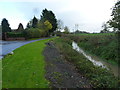
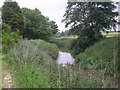
5
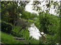
River Strine.
The river strine,at Crudgington.
Image: © Paul Beaman
Taken: 28 May 2007
0.21 miles