IMAGES TAKEN NEAR TO
Blakeway Mews, Ridgway, TELFORD, TF6 6BZ
Introduction
This page details the photographs taken nearby to Blakeway Mews, Ridgway, TF6 6BZ by members of the Geograph project.
The Geograph project started in 2005 with the aim of publishing, organising and preserving representative images for every square kilometre of Great Britain, Ireland and the Isle of Man.

There are currently over 7.5m images from over14,400 individuals and you can help contribute to the project by visiting https://www.geograph.org.uk
Image Map
Images are licensed for reuse under creativecommons.org/licenses/by-sa/2.0
Notes
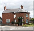
- Clicking on the map will re-center to the selected point.
- The higher the marker number, the further away the image location is from the centre of the postcode.
Image Listing (28 Images Found)
Images are licensed for reuse under creativecommons.org/licenses/by-sa/2.0
Image
Details
Distance
1
The former Cleveland Arms, High Ercall
See Image] for happier times.
Image: © JThomas
Taken: 3 Jul 2024
0.04 miles
2
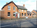
The former Cleveland Arms, High Ercall
Looks like Image has closed. Whether this happened before, or during, the 2020/2021 Covid pandemic is not entirely clear.
Image: © Richard Law
Taken: 10 Mar 2022
0.04 miles
4
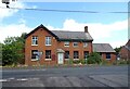
High Ercall almshouses
A group of 7 almshouses, built in 1694, to a U-shaped plan. They were Grade II listed https://britishlistedbuildings.co.uk/101374894-the-almshouses-ercall-magna#.YitwxnrP3IU & https://historicengland.org.uk/listing/the-list/list-entry/1374894 in 1983.
Image: © Richard Law
Taken: 10 Mar 2022
0.06 miles
5
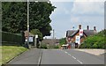
High Ercall
Entering the village along Cotwall Road.
Image: © Richard Webb
Taken: 2 Jul 2014
0.06 miles
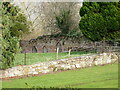
6
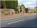
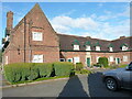
Garden boundary wall and gateway at the almshouses
Although it's been repaired and strengthened over the years, the brick wall seen here dates primarily from the late 17th century; it was built at or around the same time as the almshouses Image behind it. Grade II listed https://britishlistedbuildings.co.uk/101038619-garden-boundary-wall-gate-and-gate-piers-at-almshouses-ercall-magna#.Yity7nrP3IU & https://historicengland.org.uk/listing/the-list/list-entry/1038619 in 1983.
Image: © Richard Law
Taken: 10 Mar 2022
0.07 miles
7
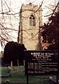
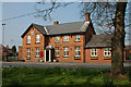
High Ercall Parish Church
Historic church of St Michael and All Angels.
Image: © Tony Smith
Taken: Unknown
0.07 miles
8
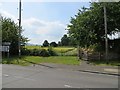
Path end, High Ercall
The edge of the village on Cotwall Road.
Image: © Richard Webb
Taken: 2 Jul 2014
0.08 miles
9
Old Toll House, High Ercall
Toll House in the parish of Ercall Magna, Toll Gate House at the junction of Cotwall Road, and Silver Hill, High Ercall, TF6 6AB.
Shropshire HER.
HER Number (PRN): 32220 https://www.heritagegateway.org.uk/Gateway/Results_Single.aspx?uid=MSA35032&resourceID=1015
Surveyed
Milestone Society National ID: SA.ERC
Image: © Milestone Society
Taken: Unknown
0.08 miles
10
Garden wall to the NE of Ercall Hall
The further (brick-built) wall in the background with the three pointed-arch doorways is the interest here; it dates from the 17th century, and surrounds the gardens of Ercall Hall. However, parts of it form the retaining wall to an earlier (probably medieval) manor house on the site. It was Grade II listed https://britishlistedbuildings.co.uk/101187230-wall-to-north-east-of-ercall-hall-ercall-magna#.YjO2kHrP3IU & https://historicengland.org.uk/listing/the-list/list-entry/1187230 in 1959.
Image: © Richard Law
Taken: 10 Mar 2022
0.10 miles