IMAGES TAKEN NEAR TO
The Glebelands, TELFORD, TF6 6BB
Introduction
This page details the photographs taken nearby to The Glebelands, TF6 6BB by members of the Geograph project.
The Geograph project started in 2005 with the aim of publishing, organising and preserving representative images for every square kilometre of Great Britain, Ireland and the Isle of Man.

There are currently over 7.5m images from over14,400 individuals and you can help contribute to the project by visiting https://www.geograph.org.uk
Image Map
Images are licensed for reuse under creativecommons.org/licenses/by-sa/2.0
Notes
- Clicking on the map will re-center to the selected point.
- The higher the marker number, the further away the image location is from the centre of the postcode.
Image Listing (28 Images Found)
Images are licensed for reuse under creativecommons.org/licenses/by-sa/2.0
Image
Details
Distance
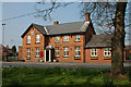
1
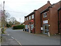
High Ercall: Post Office and hairdresser
Local shop and services in the middle of High Ercall. Old maps suggest that the PO has been located here, or very close by, for many years.
Image: © Richard Law
Taken: 10 Mar 2022
0.07 miles
2
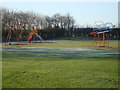
High Ercall Playground
The facilities for children at High Ercall
Image: © Rob Newman
Taken: 19 Mar 2011
0.10 miles
3
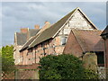
Former barns to the SW of Ercall Hall
The timber-framed barn, and the further brick barn beyond it, form part of the original farm buildings associated with Ercall Hall; they date to the 17th and 18th centuries respectively and were Grade II listed https://britishlistedbuildings.co.uk/101374389-farm-buildings-adjoining-south-west-of-ercall-hall-ercall-magna#.YjO36nrP3IU & https://historicengland.org.uk/listing/the-list/list-entry/1374389 in 1959. They are now converted to dwellings.
Image: © Richard Law
Taken: 10 Mar 2022
0.14 miles
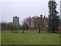
4
Ercall Hall Folly arches
These arches in the Hall grounds were investigated by the Channel 4 program "Time Team". They concluded that they were not genuine monastic ruins but a Victorian folly instead.
Image: © Paul Brooker
Taken: 26 Jun 2013
0.15 miles
5
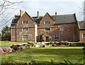
Ercall Hall
Built in 1608 for the local landowner Sir Francis Newport, on the site of an earlier moated manorhouse. The house was Grade II* listed https://britishlistedbuildings.co.uk/101187259-ercall-hall-ercall-magna#.YjO1OHrP3IU & https://historicengland.org.uk/listing/the-list/list-entry/1187259 very early in 1952.
Image: © Richard Law
Taken: 10 Mar 2022
0.15 miles
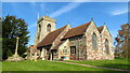
6
High Ercall Hall
Ercall hall was built in 1608 and was the site of several battles between royalists and roundheads during the English civil war. It was also the location of a Timeteam dig in 2002. Next to the hall is a 14 century Saxon church.
Image: © Roger Dean
Taken: 18 Dec 2006
0.15 miles
8

St Michaels' & All Angels Church Benchmark
The OS benchmark cut into the tower of the Grade-I listed church of St Michael's & All Angels, High Ercall, Shropshire. It is positioned towards the centre of the tower's base, approximately 0.5-metres above the ground
Image: © Anthony Rowley
Taken: 10 Oct 2021
0.17 miles
9
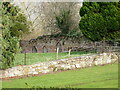
Garden wall to the NE of Ercall Hall
The further (brick-built) wall in the background with the three pointed-arch doorways is the interest here; it dates from the 17th century, and surrounds the gardens of Ercall Hall. However, parts of it form the retaining wall to an earlier (probably medieval) manor house on the site. It was Grade II listed https://britishlistedbuildings.co.uk/101187230-wall-to-north-east-of-ercall-hall-ercall-magna#.YjO2kHrP3IU & https://historicengland.org.uk/listing/the-list/list-entry/1187230 in 1959.
Image: © Richard Law
Taken: 10 Mar 2022
0.17 miles