
IMAGES TAKEN NEAR TO
Chainmakers Gate, TELFORD, TF4 3TG
Introduction
This page details the photographs taken nearby to Chainmakers Gate, TF4 3TG by members of the Geograph project.
The Geograph project started in 2005 with the aim of publishing, organising and preserving representative images for every square kilometre of Great Britain, Ireland and the Isle of Man.

There are currently over 7.5m images from over14,400 individuals and you can help contribute to the project by visiting https://www.geograph.org.uk
Image Map
Images are licensed for reuse under creativecommons.org/licenses/by-sa/2.0
Notes
- Clicking on the map will re-center to the selected point.
- The higher the marker number, the further away the image location is from the centre of the postcode.
Image Listing (17 Images Found)
Images are licensed for reuse under creativecommons.org/licenses/by-sa/2.0
Image
Details
Distance
2
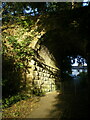
Canal aqueduct over a footpath
The aqueduct is now a bridge carrying the Silkin Way footpath. But it was originally built around 1788 as an Accommodation Bridge, to take the Shropshire Canal Navigation (a tub-boat canal) over a track; the canal was subsequently converted in the late 1850s to the Coalport Branch Line of the London & North West Railway, which then closed in 1960 and is now the Silkin Way. The bridge was Grade II listed https://britishlistedbuildings.co.uk/101377111-canal-aqueduct-at-national-grid-reference-695-057-dawley-hamlets#.YWXfLxrMLIU & https://historicengland.org.uk/listing/the-list/list-entry/1377111 in 1993, and restored in 2001.
Image: © Richard Law
Taken: 11 Oct 2021
0.06 miles
3
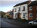
The Britannia, Aqueduct
A Banks's pub in Aqueduct village
Image: © Richard Law
Taken: 5 Dec 2009
0.07 miles
5
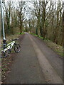
Silkin Way between Aqueduct and Brookside
The Silkin Way was designated as a north-south footpath, bridleway and cycleway in the 1970s, at a time when much of the development of Telford New Town was in progress. It runs for roughly 13 miles from Coalport in Image to Bratton in Image, often following former railway lines or canal routes. The name refers to Lord (John) Silkin, who was the Labour government Minister for Public Works and also Minister for Planning & Local Government in the early 1970s.
Image: © Richard Law
Taken: 19 Mar 2023
0.11 miles
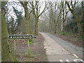
7

St Paul's Benchmark, Aqueduct
The OS Cut Benchmark on the former St Paul's Church in Aqueduct, Telford, Shropshire. The Church is refurbished to become a residential building.
Image: © Anthony Rowley
Taken: 22 Jul 2021
0.12 miles
8
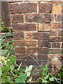
OS benchmark - Aqueduct, Methodist Hall
An OS cutmark on the south-facing wall of a small methodist chapel/hall on Aqueduct Road; originally levelled at 127.538m above Ordnance Datum Newlyn.
Image: © Richard Law
Taken: 15 Aug 2015
0.12 miles
9

Welcome sign to Telford Town Park
In my opinion, this is quite far out to be welcoming people to the "park"...
See also Image from 2023.
Image: © TCExplorer
Taken: 22 Jul 2026
0.13 miles
10
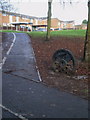
Silkin Way route marker
One of a number of loco wheels set into the ground at points along the Silkin Way, which was designated as a long-distance (well 13 miles, anyway) path through the middle of Telford new town in the 1970s. The name is in honour of John (Lord) Silkin, Minister for Planning and Local Government in the Labour government of the mid 1970s.
Image: © Richard Law
Taken: 5 Dec 2009
0.14 miles