IMAGES TAKEN NEAR TO
Lawford Close, TELFORD, TF4 3RU
Introduction
This page details the photographs taken nearby to Lawford Close, TF4 3RU by members of the Geograph project.
The Geograph project started in 2005 with the aim of publishing, organising and preserving representative images for every square kilometre of Great Britain, Ireland and the Isle of Man.

There are currently over 7.5m images from over14,400 individuals and you can help contribute to the project by visiting https://www.geograph.org.uk
Image Map
Images are licensed for reuse under creativecommons.org/licenses/by-sa/2.0
Notes
- Clicking on the map will re-center to the selected point.
- The higher the marker number, the further away the image location is from the centre of the postcode.
Image Listing (7 Images Found)
Images are licensed for reuse under creativecommons.org/licenses/by-sa/2.0
Image
Details
Distance
2

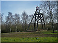
Aqueduct Roundabout
The roundabout between Aqueduct and Woodside in Telford. The roundabout has a mine headgear in the centre.
Image: © Steve McShane
Taken: 12 Nov 2005
0.18 miles
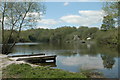
4
Little Dawley, Lower Balancing Pool in winter
Image: © Row17
Taken: 13 Jan 2010
0.20 miles

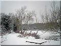
6
The Ironbridge 1/2 Marathon 2010 goes under the B4373
The Rough Park Way goes under the B4373 here, just north of Woodside.
Image: © Richard Law
Taken: 21 Mar 2010
0.24 miles
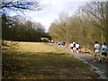
7

Entrance to the park
In the background is the distinctive outline of The Wrekin.
Image: © Row17
Taken: 2 Mar 2010
0.25 miles