IMAGES TAKEN NEAR TO
Langley Crescent, TELFORD, TF4 3QT
Introduction
This page details the photographs taken nearby to Langley Crescent, TF4 3QT by members of the Geograph project.
The Geograph project started in 2005 with the aim of publishing, organising and preserving representative images for every square kilometre of Great Britain, Ireland and the Isle of Man.

There are currently over 7.5m images from over14,400 individuals and you can help contribute to the project by visiting https://www.geograph.org.uk
Image Map (Loading...)


Getting Data...Please wait
Leaflet Map data © OpenStreetMap
Images are licensed for reuse under creativecommons.org/licenses/by-sa/2.0
Notes
- Clicking on the map will re-center to the selected point.
- The higher the marker number, the further away the image location is from the centre of the postcode.
Image Listing (18 Images Found)
Images are licensed for reuse under creativecommons.org/licenses/by-sa/2.0
Image
Details
Distance
1
Crown Street, Dawley
View WNW along Crown Street.
Image: © David P Howard
Taken: 1 Jul 2015
0.08 miles
2
Crown Street, Dawley
View ESE along Crown Street.
Image: © David P Howard
Taken: 1 Jul 2015
0.10 miles
3
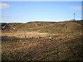
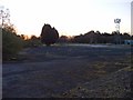
Deforestation and devastation on Paddock Mound, Dawley
The ground is being cleared in preparation for the relocation of the Phoenix School, but in the meantime it looks a bit of a mess. Compare with http://www.geograph.org.uk/photo/1227655 as an indication of how much woodland has gone for a burton. That photo was taken from the opposite direction, but the general idea is clear.
Image: © Richard Law
Taken: 14 Mar 2010
0.11 miles
4
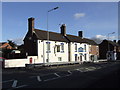
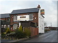
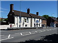
The White Horse, Dawley, Telford and Wrekin
Former Greenalls pub.
Image: © al partington
Taken: 6 Feb 2008
0.13 miles
6
Paddock Mound, Dawley
This is the site of the first offices of the Inland Revenue computerisation project in Telford. In the early 1980s it was housed in temporary buildings on this mound until purpose-built accommodation nearer the new town centre was available. Old hands (and there are precious few left) still refer to the 'Dawley days'. The buildings here passed into use by small businesses and have now been removed. Only the concrete rafts remain.
Government computerisation was privatised in the 1990s but the successor (now working for Her Majesty's Revenue and Customs) occupies many buildings in Telford and is a major employer in the town.
Image: © Mike White
Taken: 29 Mar 2009
0.14 miles
7
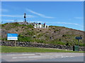
Dawleywood!
Signage erected by a local wag on the side of Paddock Mound, Dawley. The lettering has become quite a local landmark.
Image: © Richard Law
Taken: 20 Jun 2010
0.15 miles
8
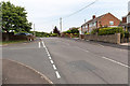
Junction on Hinkshay Road
The junction of Hinkshay Road and Crown Street, which is just in the north west corner of the grid square.
Image: © David P Howard
Taken: 1 Jul 2015
0.17 miles
9
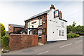
Three Crowns Inn
A public house on Hinkshay Road. The western edge of this grid square passes right through the pub.
Image: © David P Howard
Taken: 1 Jul 2015
0.18 miles