IMAGES TAKEN NEAR TO
Lancaster Avenue, TELFORD, TF4 2HT
Introduction
This page details the photographs taken nearby to Lancaster Avenue, TF4 2HT by members of the Geograph project.
The Geograph project started in 2005 with the aim of publishing, organising and preserving representative images for every square kilometre of Great Britain, Ireland and the Isle of Man.

There are currently over 7.5m images from over14,400 individuals and you can help contribute to the project by visiting https://www.geograph.org.uk
Image Map
Images are licensed for reuse under creativecommons.org/licenses/by-sa/2.0
Notes
- Clicking on the map will re-center to the selected point.
- The higher the marker number, the further away the image location is from the centre of the postcode.
Image Listing (8 Images Found)
Images are licensed for reuse under creativecommons.org/licenses/by-sa/2.0
Image
Details
Distance
1
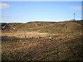
Deforestation and devastation on Paddock Mound, Dawley
The ground is being cleared in preparation for the relocation of the Phoenix School, but in the meantime it looks a bit of a mess. Compare with http://www.geograph.org.uk/photo/1227655 as an indication of how much woodland has gone for a burton. That photo was taken from the opposite direction, but the general idea is clear.
Image: © Richard Law
Taken: 14 Mar 2010
0.16 miles
2
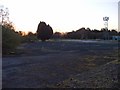
Paddock Mound, Dawley
This is the site of the first offices of the Inland Revenue computerisation project in Telford. In the early 1980s it was housed in temporary buildings on this mound until purpose-built accommodation nearer the new town centre was available. Old hands (and there are precious few left) still refer to the 'Dawley days'. The buildings here passed into use by small businesses and have now been removed. Only the concrete rafts remain.
Government computerisation was privatised in the 1990s but the successor (now working for Her Majesty's Revenue and Customs) occupies many buildings in Telford and is a major employer in the town.
Image: © Mike White
Taken: 29 Mar 2009
0.19 miles
3
Lord Hill, Dawley
Taken over by Telford & Wrekin council and doomed to be demolished to clear the route for a road running south through Dawley, it, or the facade, may yet be saved. In happier times it was: Image
Image: © Mike White
Taken: 27 Jan 2010
0.24 miles
4
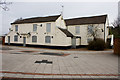
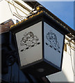
The Queen's Head, King Street, Dawley
http://www.geograph.org.uk/photo/4897090
Image: © Ian S
Taken: 31 Mar 2016
0.24 miles
5

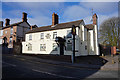
The Queen's Head, King Street, Dawley
http://www.geograph.org.uk/photo/4897088
Image: © Ian S
Taken: 31 Mar 2016
0.24 miles
7
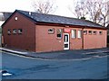
Dawley Library
This new brick building replaced the previous library, a tired temporary structure that was nevertheless an historic building: the first office of the planners of Dawley New Town (later the Telford Development Corporation). See Image for further details. The Telford Development Corporation then spent many years in Priorslee Hall Image
Image: © Mike White
Taken: 29 Mar 2009
0.25 miles
8
The Dun Cow, Dawley
It was demolished in early 2009, and the adjacent Image awaits the same fate. It had a fine bowling green with two stands for spectators: Image
Image: © Mike White
Taken: 27 Jan 2010
0.25 miles