IMAGES TAKEN NEAR TO
Ketley Town, TELFORD, TF1 5HN
Introduction
This page details the photographs taken nearby to Ketley Town, TF1 5HN by members of the Geograph project.
The Geograph project started in 2005 with the aim of publishing, organising and preserving representative images for every square kilometre of Great Britain, Ireland and the Isle of Man.

There are currently over 7.5m images from over14,400 individuals and you can help contribute to the project by visiting https://www.geograph.org.uk
Image Map
Images are licensed for reuse under creativecommons.org/licenses/by-sa/2.0
Notes
- Clicking on the map will re-center to the selected point.
- The higher the marker number, the further away the image location is from the centre of the postcode.
Image Listing (16 Images Found)
Images are licensed for reuse under creativecommons.org/licenses/by-sa/2.0
Image
Details
Distance
1
The Wren's Nest
Local boozer in Ketley.
Image: © Steve McShane
Taken: 15 Apr 2006
0.04 miles
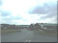
2
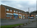
Local Shops
Local amenities for the people of Ketley.
Image: © Steve McShane
Taken: 15 Apr 2006
0.04 miles
3
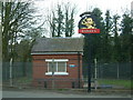
Water Pumping Station
The Wren's Nest is just to the right, and here's the sign to draw in the punters in front of a small water-pumping station. I wonder if anyone could see the irony in this photo?
Image: © Steve McShane
Taken: 15 Apr 2006
0.04 miles
4
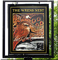
Wrens Nest, Inn Sign
A new Inn Sign for the Wrens Nest public house at Ketley Town. A great improvement on the former bland Banks's brewery sign.
Image: © Gordon Cragg
Taken: 5 May 2009
0.06 miles
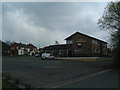
6
Ketley Business Park
Various factories and offices live here...
Image: © Steve McShane
Taken: 15 Apr 2006
0.13 miles
7
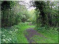
Old Railway Track
The track bed of the old GWR line at Ketley Town, this ran from Wellington to Craven Arms, via Much Wenlock. Further South, at Horsehay, part of this line is preserved by the Telford Steam Railway. http://www.telfordsteamrailway.co.uk/
Image: © Gordon Cragg
Taken: 5 May 2009
0.14 miles
8
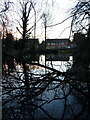
Pool at the back of houses on Morgan Way
A shallow pool at the rear of houses on Morgan Way, Ketley. There is a possibility (it's speculation on my part) that this may be the lower receiving pool for tub-boats at the bottom of the long-vanished Ketley Incline, whose location was just uphill of this point. It was used to bring tub-boats laden with coal and ore from the upper part of the Ketley Canal to a lower level, from where they moved to feed a foundry in Ketley Dingle. If this is so, then one likely contender for the route of the incline is the wooded bank shown in Image On the other hand, it could just be a random pond.
Image: © Richard Law
Taken: 1 Jan 2022
0.14 miles
9
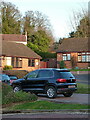
Uphill on the (probable) route of the Ketley Incline
The cars & nearest houses here are on Woodside Close, whilst the white house beyond is Hillside Farm, and dates from around 1800. The centre-line of the photo follows, as closely as I can ascertain, the line of the Ketley Incline. This was the country's first commercially-operated Inclined Plane, built around 1788 as a means of lowering tub boats from the Ketley Canal to a long-vanished foundry just to the NW of this point. The boats carried coal and ironstone to the foundry, and were lowered on L-shaped rails with a braking system managed via a windlass at the top of the plane.
Nothing remains visible at ground level of the incline, all surface signs having been removed by subsequent building works over the years, although there may be some underground traces which could be found by careful archaeology. The trustees of the Blists Hill Museum have apparently shown interest in some tunnels Image that lie beneath the garden of Hillside Farm, although whether these are associated with the incline is unknown.
Image: © Richard Law
Taken: 1 Jan 2022
0.16 miles
10
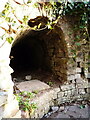
Mysterious tunnel entrance
Right outside the rear of Hillside Farm lies this tunnel entrance - roughly 2'6" wide and 3' high. It heads off in an easterly direction for maybe 20 yards, then opens up into a high chamber Image, from which it then takes a more northerly direction towards Ketley Hall, although local knowledge suggests that the far end of it has long since been closed off. Purpose and original use are unknown, but it is neatly brick-lined throughout (albeit a bit dirty on the floor) and 'feels old' in the sense that it's probably 18th century or thereabouts. Given that the whole area was heavily mined for coal, ironstone and various other minerals in the 18th & 19th centuries, it's quite likely to have been some sort of drain for a nearby mine. It also lies very close to the site of the former Ketley Canal Incline, all surface trace of which has now vanished. The Blists Hill Museum staff have investigated it in the past, but I have not tracked down their conclusions yet.
Image: © Richard Law
Taken: 1 Jan 2022
0.18 miles