Mysterious tunnel entrance
Introduction
The photograph on this page of Mysterious tunnel entrance by Richard Law as part of the Geograph project.
The Geograph project started in 2005 with the aim of publishing, organising and preserving representative images for every square kilometre of Great Britain, Ireland and the Isle of Man.

There are currently over 7.5m images from over 14,400 individuals and you can help contribute to the project by visiting https://www.geograph.org.uk
Mysterious tunnel entrance
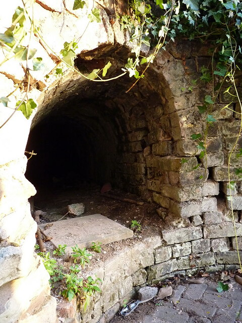
Image: © Richard Law Taken: 1 Jan 2022
Right outside the rear of Hillside Farm lies this tunnel entrance - roughly 2'6" wide and 3' high. It heads off in an easterly direction for maybe 20 yards, then opens up into a high chamber Image, from which it then takes a more northerly direction towards Ketley Hall, although local knowledge suggests that the far end of it has long since been closed off. Purpose and original use are unknown, but it is neatly brick-lined throughout (albeit a bit dirty on the floor) and 'feels old' in the sense that it's probably 18th century or thereabouts. Given that the whole area was heavily mined for coal, ironstone and various other minerals in the 18th & 19th centuries, it's quite likely to have been some sort of drain for a nearby mine. It also lies very close to the site of the former Ketley Canal Incline, all surface trace of which has now vanished. The Blists Hill Museum staff have investigated it in the past, but I have not tracked down their conclusions yet.
Images are licensed for reuse under creativecommons.org/licenses/by-sa/2.0
Image Location
Latitude
52.692821
Longitude
-2.477605