IMAGES TAKEN NEAR TO
Stanton Long, MUCH WENLOCK, TF13 6LQ
Introduction
This page details the photographs taken nearby to TF13 6LQ by members of the Geograph project.
The Geograph project started in 2005 with the aim of publishing, organising and preserving representative images for every square kilometre of Great Britain, Ireland and the Isle of Man.

There are currently over 7.5m images from over14,400 individuals and you can help contribute to the project by visiting https://www.geograph.org.uk
Image Map
Images are licensed for reuse under creativecommons.org/licenses/by-sa/2.0
Notes
- Clicking on the map will re-center to the selected point.
- The higher the marker number, the further away the image location is from the centre of the postcode.
Image Listing (82 Images Found)
Images are licensed for reuse under creativecommons.org/licenses/by-sa/2.0
Image
Details
Distance
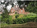
2
Glebe Farm, Stanton Long
Handsome Victorian farmhouse, seen from the churchyard.
Image: © Philip Pankhurst
Taken: 27 Dec 2015
0.15 miles
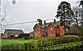
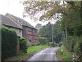
3
Stanton Long House
South of Glebe Farm is Stanton Long House, a grand Victorian building from the nineteenth century that is north-east from the parish church. Taken by the exterior of the east-end window at that church.
Image: © Fabian Musto
Taken: 2 Sep 2021
0.15 miles
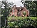
4
Stanton Long House
South of Glebe Farm is Stanton Long House, a grand Victorian building from the nineteenth century that is north-east from the parish church.
Image: © Fabian Musto
Taken: 2 Sep 2021
0.15 miles
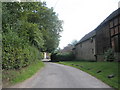
8

Tithe House (Stanton Long)
Here is a glimpse of Tithe House from the steps to St. Michael parish church, presumably built during the seventeenth century. The part timber-framed and weatherboarded barn was grade II listed in March 1970.
Image: © Fabian Musto
Taken: 2 Sep 2021
0.18 miles
9
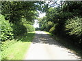
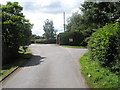
Lane at Stanton Long
Here is a country lane at Stanton Long, which passes by the parish church of St. Michael. In the distance to the left is Image
Image: © Fabian Musto
Taken: 2 Sep 2021
0.18 miles
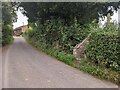
10
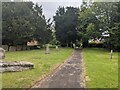
Path to St. Michael and All Angels church (Stanton Long)
Here is the path to Stanton Long parish church from the south-east, with several yew trees in view.
Image: © Fabian Musto
Taken: 2 Sep 2021
0.18 miles