IMAGES TAKEN NEAR TO
East Wall, MUCH WENLOCK, TF13 6DU
Introduction
This page details the photographs taken nearby to TF13 6DU by members of the Geograph project.
The Geograph project started in 2005 with the aim of publishing, organising and preserving representative images for every square kilometre of Great Britain, Ireland and the Isle of Man.

There are currently over 7.5m images from over14,400 individuals and you can help contribute to the project by visiting https://www.geograph.org.uk
Image Map (Loading...)


Getting Data...Please wait
Leaflet Map data © OpenStreetMap
Images are licensed for reuse under creativecommons.org/licenses/by-sa/2.0
Notes
- Clicking on the map will re-center to the selected point.
- The higher the marker number, the further away the image location is from the centre of the postcode.
Image Listing (7 Images Found)
Images are licensed for reuse under creativecommons.org/licenses/by-sa/2.0
Image
Details
Distance
4
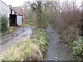
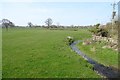
Brook at East Wall
The hamlet of East Wall consists of three farms clustered around this unnamed brook.
Image: © Jonathan Billinger
Taken: 6 Dec 2007
0.09 miles
6
Field seen from East Bridge
Grassland and an unusual brook, not fringed by trees.
Image: © Richard Webb
Taken: 1 Apr 2019
0.21 miles
7
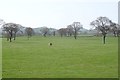
Signs of amalgamation
A big field made up by removing hedges. Mature trees were left standing.
Image: © Richard Webb
Taken: 1 Apr 2019
0.23 miles