IMAGES TAKEN NEAR TO
TF1 1XF
Introduction
This page details the photographs taken nearby to TF1 1XF by members of the Geograph project.
The Geograph project started in 2005 with the aim of publishing, organising and preserving representative images for every square kilometre of Great Britain, Ireland and the Isle of Man.

There are currently over 7.5m images from over14,400 individuals and you can help contribute to the project by visiting https://www.geograph.org.uk
Image Map
Images are licensed for reuse under creativecommons.org/licenses/by-sa/2.0
Notes
- Clicking on the map will re-center to the selected point.
- The higher the marker number, the further away the image location is from the centre of the postcode.
Image Listing (14 Images Found)
Images are licensed for reuse under creativecommons.org/licenses/by-sa/2.0
Image
Details
Distance
1
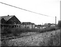
Old iron foundry near Trench Lock, Shropshire
This large works had already closed when the photograph was taken in 1963. It had a rail connection, via level crossing across the A518, to the ex-LNWR Wellington- Stafford line. The Trench Branch of the Shropshire Union Canal, disused and heavily overgrown, is between the photographer and the works, with Trench Lock just off-picture to the right. The area is now buried beneath a dual carriageway.
Image: © Dr Neil Clifton
Taken: 7 Apr 1963
0.07 miles
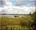
3
Trench Branch, Shropshire Union Canal, near Trench Lock
This shows the branch below the foot of Trench Inclined Plane. The canal has been derelict for many years. The disused iron works on the left has still not been cleared away. A dual carriageway now obscures all of this area.
Image: © Dr Neil Clifton
Taken: 4 Sep 1966
0.11 miles
4
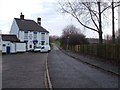
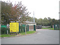
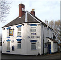
The Blue Pig
I have tried to duplicate the same view as the older photograph on this square. The Shrewsbury canal has long gone, and the height of the incline plane much reduced.
Image: © Roger Dean
Taken: 30 Dec 2006
0.12 miles
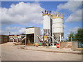
5
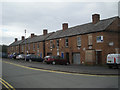
For Sale at Trench Lock
These buildings behind Telford Car Auctions are on prime industrial redevelopment land near to a major access to the A442 which is a main access highway to the M54.
Image: © Row17
Taken: 6 Oct 2008
0.15 miles
6
The 'Shropshire Arms' and Trench Incline, Shropshire
This most interesting photograph, taken some 40 years ago, shows the Shropshire Arms on the left, with the remains of the Trench canal incline to the right. By this incline, tub boats from the high level canal system of the Shropshire coalfield were lowered into the Shropshire Canal (not to be confused with the much later Shropshire Union Canal). At the foot of the incline, the coal was transshipped into special 'narrow' narrow boats, only 6ft 4ins wide to negotiate the very narrow locks of the Trench Branch. Seen behind the pub are cottages known as Trench Pool Bank, already unoccupied. All around here is now much changed: the pub is now the 'Blue Pig' (see the other picture for this square). The cottages have been demolished, and a dual-carriageway road now runs where the incline once was.
Image: © Dr Neil Clifton
Taken: 10 Aug 1966
0.19 miles
7
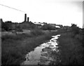
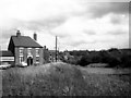
Trench Pool, Shropshire
Once a canal reservoir: later used for fishing and by the local Sea Cadets.
Image: © Dr Neil Clifton
Taken: 15 Aug 1963
0.19 miles
9
The Blue Pig Capewell Road
Formerly known as The Shropshire Arms, in spite of the Pub Sign, the name "Blue Pig" has nothing to do with farming but refers to the pig iron produced in the iron works that used to be nearby. Image http://ne-telford-pubs.fotopic.net/
Image: © Gordon Cragg
Taken: 20 Nov 2008
0.22 miles
10
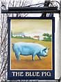
The Blue Pig Pub Sign Capewell Road
Not the type of Blue Pig that the pub was named after, that should be a piece of pig iron! Image http://ne-telford-pubs.fotopic.net/
Image: © Gordon Cragg
Taken: 20 Nov 2008
0.23 miles