The 'Shropshire Arms' and Trench Incline, Shropshire
Introduction
The photograph on this page of The 'Shropshire Arms' and Trench Incline, Shropshire by Dr Neil Clifton as part of the Geograph project.
The Geograph project started in 2005 with the aim of publishing, organising and preserving representative images for every square kilometre of Great Britain, Ireland and the Isle of Man.

There are currently over 7.5m images from over 14,400 individuals and you can help contribute to the project by visiting https://www.geograph.org.uk
The 'Shropshire Arms' and Trench Incline, Shropshire
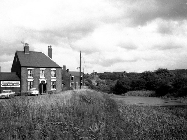
Image: © Dr Neil Clifton Taken: 10 Aug 1966
This most interesting photograph, taken some 40 years ago, shows the Shropshire Arms on the left, with the remains of the Trench canal incline to the right. By this incline, tub boats from the high level canal system of the Shropshire coalfield were lowered into the Shropshire Canal (not to be confused with the much later Shropshire Union Canal). At the foot of the incline, the coal was transshipped into special 'narrow' narrow boats, only 6ft 4ins wide to negotiate the very narrow locks of the Trench Branch. Seen behind the pub are cottages known as Trench Pool Bank, already unoccupied. All around here is now much changed: the pub is now the 'Blue Pig' (see the other picture for this square). The cottages have been demolished, and a dual-carriageway road now runs where the incline once was.
Images are licensed for reuse under creativecommons.org/licenses/by-sa/2.0
Image Location
Latitude
52.707454
Longitude
-2.464696