IMAGES TAKEN NEAR TO
Silvermere Park, SHIFNAL, TF11 9BW
Introduction
This page details the photographs taken nearby to Silvermere Park, TF11 9BW by members of the Geograph project.
The Geograph project started in 2005 with the aim of publishing, organising and preserving representative images for every square kilometre of Great Britain, Ireland and the Isle of Man.

There are currently over 7.5m images from over14,400 individuals and you can help contribute to the project by visiting https://www.geograph.org.uk
Image Map (Loading...)


Getting Data...Please wait
Leaflet Map data © OpenStreetMap
Images are licensed for reuse under creativecommons.org/licenses/by-sa/2.0
Notes
- Clicking on the map will re-center to the selected point.
- The higher the marker number, the further away the image location is from the centre of the postcode.
Image Listing (251 Images Found)
Images are licensed for reuse under creativecommons.org/licenses/by-sa/2.0
Image
Details
Distance
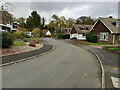
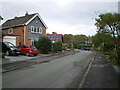
2
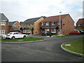
Houses on Meadway
1970s/1980s housing on the Meadway part of Silvermere Park estate. It's a very quiet part of town, aside from the occasional rumble of a train on the embankment in the trees behind the houses on the left.
Image: © Richard Law
Taken: 13 Nov 2021
0.06 miles
3
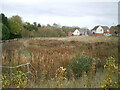
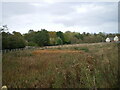
Drainage pond for new housing
It's barely visible as such in this photo as there's been little rain for some weeks, but the area of reeds and rushes in front here is a large attenuation pond, constructed to take surface drainage from the new housing estate to the south of this point.
Image: © Richard Law
Taken: 29 Oct 2021
0.06 miles
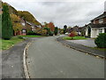
4
Small green space behind houses on Meadway
The dropped kerb rather suggests that this small plot may once have been earmarked for a house, but it's never happened yet in 30-odd years. I suspect the surrounding residents look after the trees, grass and shrubs.
Image: © Richard Law
Taken: 13 Nov 2021
0.06 miles
6
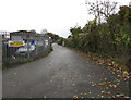
The Railway Sidings, Shifnal
Industrial/business area between Aston Street and railway lines, east of Shifnal railway station.
Image: © Jaggery
Taken: 9 Nov 2015
0.07 miles
7
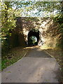
Railway accommodation bridge
Originally installed to allow farm access to lands either side of the railway, but now repurposed to a footpath between housing developments.
Image: © Richard Law
Taken: 3 Nov 2021
0.08 miles
8
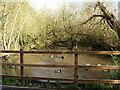
Old pond just south of the railway
A small flock of ducks, probably quite well fed by the residents of the nearby housing, inhabit this old pond which is marked on the maps of 1882 and 1901. Could do with some of the fallen trees removing from it, in my opinion.
Image: © Richard Law
Taken: 3 Nov 2021
0.08 miles
9
Another drainage pond
A second attenuation pond area, built in addition to the one just to the NE Image, which stores runoff from new housing nearby.
Image: © Richard Law
Taken: 29 Oct 2021
0.08 miles
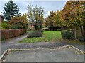
10
Mountford Way houses
A cul-de-sac housing development off Stone Drive
Image: © Richard Law
Taken: 29 Oct 2021
0.10 miles