IMAGES TAKEN NEAR TO
Bluebell Way, SHIFNAL, TF11 8FD
Introduction
This page details the photographs taken nearby to Bluebell Way, TF11 8FD by members of the Geograph project.
The Geograph project started in 2005 with the aim of publishing, organising and preserving representative images for every square kilometre of Great Britain, Ireland and the Isle of Man.

There are currently over 7.5m images from over14,400 individuals and you can help contribute to the project by visiting https://www.geograph.org.uk
Image Map
Images are licensed for reuse under creativecommons.org/licenses/by-sa/2.0
Notes
- Clicking on the map will re-center to the selected point.
- The higher the marker number, the further away the image location is from the centre of the postcode.
Image Listing (87 Images Found)
Images are licensed for reuse under creativecommons.org/licenses/by-sa/2.0
Image
Details
Distance
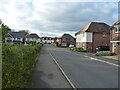
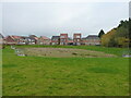
1
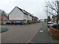
Houses on Bluebell Way
Much new development has been taking place in this area of Shifnal over the last few years; these are typical of the houses that have been built here.
Image: © Richard Law
Taken: 23 Nov 2021
0.01 miles
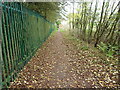
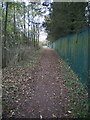
2
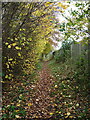
The Butts, Shifnal
A footpath that runs behind new housing (on the left) and the industrial estate (behind the steel fencing); on the 1:2500 map of 1901 it's marked as Lawton Road, and appears to be a narrow country lane or path connecting the Smithfield cattle market area to Lamledge Lane near the railway bridge.
Image: © Richard Law
Taken: 23 Nov 2021
0.03 miles
4
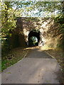
Railway accommodation bridge
Originally installed to allow farm access to lands either side of the railway, but now repurposed to a footpath between housing developments.
Image: © Richard Law
Taken: 3 Nov 2021
0.06 miles
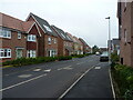
5
Houses on Bluebell Way
A new housing estate, built around 2017 or soon after.
Image: © Richard Law
Taken: 3 Nov 2021
0.07 miles
6
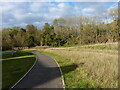
Pathway north of Stone Drive
Part of the path network that's been built to provide walks between all the houses in the new estates here on the southeast side of Shifnal. The railway line runs along the wooded embankment in the background.
Image: © Richard Law
Taken: 3 Nov 2021
0.08 miles
7
West along The Butts path
Once known as Lawton Lane, and now a footpath between new housing and the local industrial estate.
Image: © Richard Law
Taken: 23 Nov 2021
0.08 miles
8
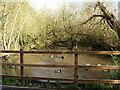
Old pond just south of the railway
A small flock of ducks, probably quite well fed by the residents of the nearby housing, inhabit this old pond which is marked on the maps of 1882 and 1901. Could do with some of the fallen trees removing from it, in my opinion.
Image: © Richard Law
Taken: 3 Nov 2021
0.09 miles
9
Balancing pond or urban drainage pool
A small pool constructed as part of the nearby housing developments, presumably intended to take surface run-off of rainwater and slow its arrival in the local watercourses.
Image: © Richard Law
Taken: 23 Nov 2021
0.09 miles
10
The Butts path
Marked on older maps as Lawton Lane, at which time it ran across open fields between Lamledge Lane at the eastern end and the Smithfield cattle market area on the western outskirts of Shifnal. The fields are now all covered in housing.
Image: © Richard Law
Taken: 24 Nov 2021
0.10 miles