IMAGES TAKEN NEAR TO
Bolams Brook, NEWPORT, TF10 9BE
Introduction
This page details the photographs taken nearby to Bolams Brook, TF10 9BE by members of the Geograph project.
The Geograph project started in 2005 with the aim of publishing, organising and preserving representative images for every square kilometre of Great Britain, Ireland and the Isle of Man.

There are currently over 7.5m images from over14,400 individuals and you can help contribute to the project by visiting https://www.geograph.org.uk
Image Map
Images are licensed for reuse under creativecommons.org/licenses/by-sa/2.0
Notes
- Clicking on the map will re-center to the selected point.
- The higher the marker number, the further away the image location is from the centre of the postcode.
Image Listing (3 Images Found)
Images are licensed for reuse under creativecommons.org/licenses/by-sa/2.0
Image
Details
Distance
2
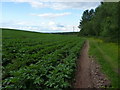
Footpath near The Roundabout
The squarish copse to the north of this path alongside the potato field is called The Roundabout; no idea why. The valley that the path run in also forms the boundary between Shropshire Council and the Telford & Wrekin Unitary Authority.
Image: © Richard Law
Taken: 11 Jun 2011
0.18 miles
3
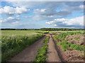
Tracks across fields at Lynn
Rough farm tracks across the fields; this area has been used in the fairly recent past to grow flowers for the florist trade, so the occasional large bloom still crops up amongst the wheat or rapeseed.
Image: © Richard Law
Taken: 11 Jun 2011
0.24 miles