IMAGES TAKEN NEAR TO
Child Pits, NEWPORT, TF10 9AR
Introduction
This page details the photographs taken nearby to Child Pits, TF10 9AR by members of the Geograph project.
The Geograph project started in 2005 with the aim of publishing, organising and preserving representative images for every square kilometre of Great Britain, Ireland and the Isle of Man.

There are currently over 7.5m images from over14,400 individuals and you can help contribute to the project by visiting https://www.geograph.org.uk
Image Map
Images are licensed for reuse under creativecommons.org/licenses/by-sa/2.0
Notes
- Clicking on the map will re-center to the selected point.
- The higher the marker number, the further away the image location is from the centre of the postcode.
Image Listing (9 Images Found)
Images are licensed for reuse under creativecommons.org/licenses/by-sa/2.0
Image
Details
Distance
1
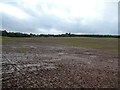
Fields near the National Sports Centre at Lilleshall
A nice space.
Image: © Jeremy Bolwell
Taken: 1 Nov 2023
0.06 miles
2
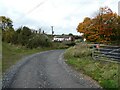
Bridleway into Childpit Lane
Childpit Lane - a small collection of rural cottages and farm buildings, normally accessed via a track from the Lilleshall Hall drive, but also from the SW via this bridleway.
Image: © Richard Law
Taken: 7 Jan 2012
0.06 miles
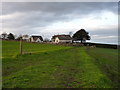
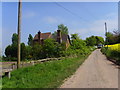
4
Childpit Farm
The small hamlet of Childpit from the disused track to the west.
Image: © Richard Law
Taken: 7 Jan 2012
0.12 miles
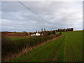
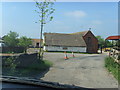
5
Track into and out of Child Pit Farm
Interesting looking place. Nice stable block.
Image: © Jeremy Bolwell
Taken: 1 Nov 2023
0.12 miles
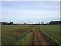
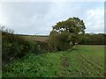
6
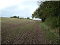
Field edge
Nice walking near the new crop.
Image: © Jeremy Bolwell
Taken: 1 Nov 2023
0.13 miles
7
Lilleshall Equestrian Centre
Childs Pit Lane
Image: © A Holmes
Taken: 3 May 2007
0.14 miles
9
Field edge
I am looking for a gap in the hedge to gain access to the field adjacent. I found it.
Image: © Jeremy Bolwell
Taken: 1 Nov 2023
0.24 miles