IMAGES TAKEN NEAR TO
Roe Deer Green, NEWPORT, TF10 7JQ
Introduction
This page details the photographs taken nearby to Roe Deer Green, TF10 7JQ by members of the Geograph project.
The Geograph project started in 2005 with the aim of publishing, organising and preserving representative images for every square kilometre of Great Britain, Ireland and the Isle of Man.

There are currently over 7.5m images from over14,400 individuals and you can help contribute to the project by visiting https://www.geograph.org.uk
Image Map
Images are licensed for reuse under creativecommons.org/licenses/by-sa/2.0
Notes
- Clicking on the map will re-center to the selected point.
- The higher the marker number, the further away the image location is from the centre of the postcode.
Image Listing (9 Images Found)
Images are licensed for reuse under creativecommons.org/licenses/by-sa/2.0
Image
Details
Distance
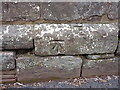
1
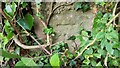
Benchmark on Chetwynd Road
The Ordnance Survey Benchmark cut into the roadside wall on Chetwynd Road, Newport, Shropshire. It was last verified by the OS in 1961
Image: © Anthony Rowley
Taken: 15 Jun 2022
0.05 miles
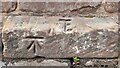
2
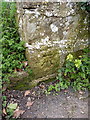
OS benchmark, Chetwynd road
An OS cutmark in the stonework of the wall next to the Cheneyhill footpath; originally levelled at 79.733m above Ordnance Datum Newlyn.
Image: © Richard Law
Taken: 14 Mar 2014
0.05 miles
3
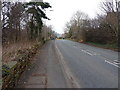
The old A41
The Chetwynd Road, formerly the A41 main route north to Chester, just outside Newport.
Image: © Richard Law
Taken: 14 Mar 2014
0.06 miles
5
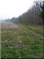
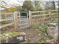
Footpath to Cheneyhill
Heading westwards along the southern edge of Alder Covet, towards Cheneyhill.
Image: © Richard Law
Taken: 14 Mar 2014
0.11 miles
6
Benchmark on Chester Road, Newport
The Ordnance Survey Benchmark is cut into the sandstone wall that runs alongside the Chester Road bordering the Park Pool. The Benchmark was last verified by the OS in 1961
Image: © Anthony Rowley
Taken: 15 Jun 2022
0.20 miles
7
OS benchmark, Chetwynd Road by Park Pool
A well-formed OS cutmark in the stonework of the wall bounding the former A41 northbound; originally levelled at 72.043m above Ordnance Datum Newlyn.
Image: © Richard Law
Taken: 14 Mar 2014
0.20 miles
8
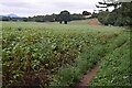
Field edge south of Park Pool
The distinctive shape of The Wrekin is visible in the distance.
Image: © David Martin
Taken: 30 Jul 2022
0.21 miles
9
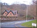
Park Pool Cottage
Cottage overlooking Chetwynd pool.
Image: © Roger Dean
Taken: 1 Jan 2007
0.24 miles