IMAGES TAKEN NEAR TO
HAWICK, TD9 9UG
Introduction
This page details the photographs taken nearby to TD9 9UG by members of the Geograph project.
The Geograph project started in 2005 with the aim of publishing, organising and preserving representative images for every square kilometre of Great Britain, Ireland and the Isle of Man.

There are currently over 7.5m images from over14,400 individuals and you can help contribute to the project by visiting https://www.geograph.org.uk
Image Map
Images are licensed for reuse under creativecommons.org/licenses/by-sa/2.0
Notes
- Clicking on the map will re-center to the selected point.
- The higher the marker number, the further away the image location is from the centre of the postcode.
Image Listing (9 Images Found)
Images are licensed for reuse under creativecommons.org/licenses/by-sa/2.0
Image
Details
Distance
1
Hummelknowehaugh
This is a view from the B6399
Image: © Walter Baxter
Taken: 9 Oct 2006
0.00 miles
2
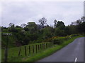
Road and farm house at Flex
South of Hawick on the B6399
Image: © James Denham
Taken: 2 Jun 2008
0.07 miles
4
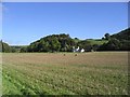
Flex Burn and Hummelknowehaugh
'Haugh' refers to flat land near a river, in this case the Slitrig Water, a tributary of the River Teviot. The hill beyond is Castle Law, which has one of the several hill forts along this valley.
Image: © Jim Barton
Taken: 2 Feb 2013
0.09 miles
5
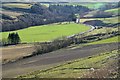
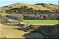
Valley of the Slitrig Water
The B6399 road follows the Slitrig valley south from Hawick, which was also the route used by the Waverley railway line on its way to Carlisle. The viewpoint is on the track down to Flex farm.
Image: © Jim Barton
Taken: 2 Feb 2013
0.15 miles
6
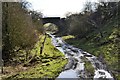
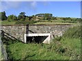
Bridge over the former Waverley railway line
A farm track bridge near Flex on the route of the Waverley Line in the valley of the Slitrig Water.
Image: © Jim Barton
Taken: 2 Feb 2013
0.19 miles
7
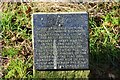
Roadside plaque, Flex
A plaque commemorating the old common boundary of Hawick, which still celebrates with the first of the Border Common Ridings; see the Hawick Common Riding website at http://www.hawickcommonriding.com/ for much more on the history and present day ceremonies.
Image: © Jim Barton
Taken: 2 Feb 2013
0.24 miles
8
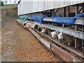
Sheep at Flex farm
Sheep at this hill farm south of Hawick.
Image: © Jim Barton
Taken: 28 Jan 2022
0.24 miles
9
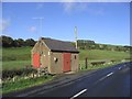
An electricity sub-station building by the B6399
Image: © Walter Baxter
Taken: 9 Oct 2006
0.24 miles