IMAGES TAKEN NEAR TO
HAWICK, TD9 8RU
Introduction
This page details the photographs taken nearby to TD9 8RU by members of the Geograph project.
The Geograph project started in 2005 with the aim of publishing, organising and preserving representative images for every square kilometre of Great Britain, Ireland and the Isle of Man.

There are currently over 7.5m images from over14,400 individuals and you can help contribute to the project by visiting https://www.geograph.org.uk
Image Map
Images are licensed for reuse under creativecommons.org/licenses/by-sa/2.0
Notes
- Clicking on the map will re-center to the selected point.
- The higher the marker number, the further away the image location is from the centre of the postcode.
Image Listing (23 Images Found)
Images are licensed for reuse under creativecommons.org/licenses/by-sa/2.0
Image
Details
Distance
1
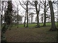
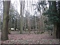
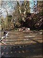
Grazed woodland, Hassendeanburn
There is no undergrowth due to grazing. This is a wood that surrounds land which was once a park.
Image: © Richard Webb
Taken: 14 Mar 2008
0.07 miles
3
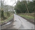
Road heading north between Hassendeanburn and Glenteviot
In Roxburghshire.
Image: © James Denham
Taken: 15 Mar 2012
0.11 miles
5
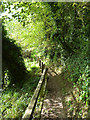
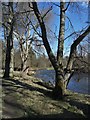
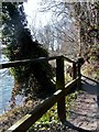
Border Abbeys Way
Here the Border Abbeys Way, a circular long-distance walking route in the Scottish Borders runs alongside the River Teviot. Boardwalks have been constructed at several points along the river where the ground is too wet.
Image: © Oliver Dixon
Taken: 22 Sep 2014
0.13 miles
9
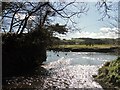
The Hassendean Burn enters the River Teviot
Image: © Iain Lees
Taken: 18 Mar 2011
0.17 miles
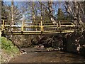
10
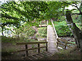
Footbridge over the Hassendean Burn
This footbridge carries the Border Abbeys Way, a circular long-distance walking route in the Scottish Borders.
Image: © Oliver Dixon
Taken: 22 Sep 2014
0.17 miles