IMAGES TAKEN NEAR TO
Ettrickhaugh Cottages, SELKIRK, TD7 5AY
Introduction
This page details the photographs taken nearby to Ettrickhaugh Cottages, TD7 5AY by members of the Geograph project.
The Geograph project started in 2005 with the aim of publishing, organising and preserving representative images for every square kilometre of Great Britain, Ireland and the Isle of Man.

There are currently over 7.5m images from over14,400 individuals and you can help contribute to the project by visiting https://www.geograph.org.uk
Image Map
Images are licensed for reuse under creativecommons.org/licenses/by-sa/2.0
Notes
- Clicking on the map will re-center to the selected point.
- The higher the marker number, the further away the image location is from the centre of the postcode.
Image Listing (36 Images Found)
Images are licensed for reuse under creativecommons.org/licenses/by-sa/2.0
Image
Details
Distance
2
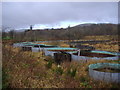
Mill lade junction, former fish farm at Philiphaugh
The lade from the waterwheel near Murray's Cauld split into two branches around the former Philiphaugh textile mill, reuniting at this point. The old mill area has been used as a fish farm but this now appears to have ceased operation. See Image taken in 2007.
Image: © Jim Barton
Taken: 15 Jan 2019
0.05 miles
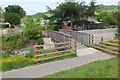
3
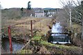
Mill lade, Selkirk
The lade carries water from Murray's Cauld, Philiphaugh, where the large waterwheel powered a sawmill and threshing mill, and discharges to the Ettrick Water near the road bridge. In the centre is the footbridge that was renewed as part of the flood protection works.
Image: © Jim Barton
Taken: 11 Dec 2016
0.05 miles
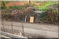
4
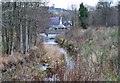
New path and temporary dam, Philiphaugh mill lade
A new tarmac path has been made along the embankment built as part of the Flood Protection Scheme. The lade has been dammed here to permit construction of new flood defence walls downstream, before the lade joins the Ettrick Water.
Image: © Jim Barton
Taken: 28 Oct 2015
0.06 miles
5
Footbridge-in-waiting, Ettrickhaugh
The new footbridge, built by a Dutch company, in a compound near the Philiphaugh mill lade. It is part of the works for the Selkirk Flood Protection Scheme. See Image for the site of the bridge on the path from Selkirk to Philiphaugh.
Image: © Jim Barton
Taken: 28 Oct 2015
0.06 miles
6
Replacement footbridge over the mill lade, Philip Haugh
The previous bridge is shown in Image taken in 2010. This bridge was installed as part of the flood protection scheme officially opened earlier this year.
Image: © Jim Barton
Taken: 28 May 2017
0.08 miles
7
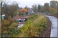
Footbridge removed, Philiphaugh mill lade
The footbridge from Ettrickhaugh Road over the mill lade has been removed during the flood protection work. The lade has been temporarily dammed a short distance upstream, and there is a new bridge nearby awaiting installation.
See Image for the original bridge in 2010.
Image: © Jim Barton
Taken: 28 Oct 2015
0.08 miles
8
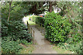
Footbridge over the mill lade, Selkirk
There's a choice of paths here westwards, either following the lade or the N bank of the Ettrick Water.
Image: © Jim Barton
Taken: 6 Jul 2010
0.08 miles
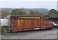
9
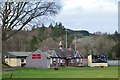
Selkirk Cricket Club Pavilion
A traditional-style pavilion on the field at Philip Haugh.
Image: © Jim Barton
Taken: 15 Jan 2019
0.08 miles
10
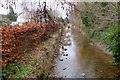
Lade near Philip Haugh, Ettrick Water
The lade carried water from Murray's Cauld to power a sawmill and a threshing mill on the Philiphaugh Estate. It rejoins the Ettrick Water near the road bridge.
Image: © Jim Barton
Taken: 9 Mar 2014
0.13 miles