IMAGES TAKEN NEAR TO
Eildonbank, MELROSE, TD6 9HH
Introduction
This page details the photographs taken nearby to Eildonbank, TD6 9HH by members of the Geograph project.
The Geograph project started in 2005 with the aim of publishing, organising and preserving representative images for every square kilometre of Great Britain, Ireland and the Isle of Man.

There are currently over 7.5m images from over14,400 individuals and you can help contribute to the project by visiting https://www.geograph.org.uk
Image Map
Images are licensed for reuse under creativecommons.org/licenses/by-sa/2.0
Notes
- Clicking on the map will re-center to the selected point.
- The higher the marker number, the further away the image location is from the centre of the postcode.
Image Listing (23 Images Found)
Images are licensed for reuse under creativecommons.org/licenses/by-sa/2.0
Image
Details
Distance
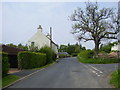
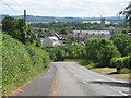
1
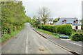
Houses on the outskirts of Eildon
Eildon is a small village to the north of Newton St Boswells, perhaps too small to be thought of as having outskirts! The main part of the settlement lies ahead in the image; Newton St Boswells is about one kilometre behind the camera position.
Image: © Trevor Littlewood
Taken: 2 May 2019
0.02 miles
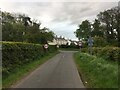
2

Cyclists on the old A6091 at Eildon village
The hilly and tortuous A6091 Melrose to Newtown St Boswells Road was closed when the new Melrose By-pass was built. The road now forms an attractive if hilly route for walkers on the Borders Abbeys Way and for cyclists on National Cycle Network route 1.
Image: © Oliver Dixon
Taken: 5 May 2014
0.04 miles
3
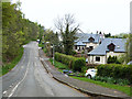
Eildon village
The hilly and tortuous A6091 Melrose to Newtown St Boswells Road was closed when the new Melrose By-pass was built. The road now forms cul-de-sac access to Eildon village, and an attractive if hilly route for walkers on the Borders Abbeys Way and for cyclists on National Cycle Network route 1.
Image: © Oliver Dixon
Taken: 5 May 2014
0.05 miles
4
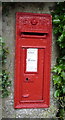
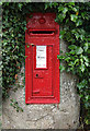
Edward VII postbox, Eildon
Postbox No. TD6 67.
See Image] for context.
Image: © JThomas
Taken: 25 Jun 2016
0.05 miles
5
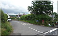
Minor road, Eildon
Showing position of Postbox No. TD6 67.
See Image] for postbox.
Image: © JThomas
Taken: 25 Jun 2016
0.05 miles
6
Edwardian postbox at Eildon village
This Edward VII postbox is located at a crossroads in the village.
Image: © Walter Baxter
Taken: 29 Jun 2008
0.06 miles
7
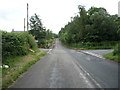
National Cycle Route 1, Eildon
Looking south east.
Image: © JThomas
Taken: 25 Jun 2016
0.06 miles
9
Village of Eildon
This ancient settlement sits in the shadow of the mighty Eildon Hills, the legendary 'Fairyland' of Thomas the Rhymer.
Image: © James Denham
Taken: 23 May 2008
0.07 miles
10
The old A6091
Descent into Newtown St Boswells from Eildon. The road is still open here, serving Eildon, but is closed to motorised traffic just north of Eildon.
Image: © Richard Webb
Taken: 29 Jun 2010
0.12 miles