IMAGES TAKEN NEAR TO
Hawkslee Park, MELROSE, TD6 0PR
Introduction
This page details the photographs taken nearby to Hawkslee Park, TD6 0PR by members of the Geograph project.
The Geograph project started in 2005 with the aim of publishing, organising and preserving representative images for every square kilometre of Great Britain, Ireland and the Isle of Man.

There are currently over 7.5m images from over14,400 individuals and you can help contribute to the project by visiting https://www.geograph.org.uk
Image Map (Loading...)


Getting Data...Please wait
Leaflet Map data © OpenStreetMap
Images are licensed for reuse under creativecommons.org/licenses/by-sa/2.0
Notes
- Clicking on the map will re-center to the selected point.
- The higher the marker number, the further away the image location is from the centre of the postcode.
Image Listing (77 Images Found)
Images are licensed for reuse under creativecommons.org/licenses/by-sa/2.0
Image
Details
Distance
1
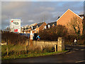
New housing at Newtown St Boswells
These houses at Hawkslee Park are being built on a triangular piece of ground between the B6398 and the A68 at the east side of Newtown St Boswells.
Image: © Walter Baxter
Taken: 15 Nov 2009
0.03 miles
2
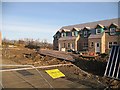
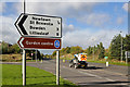
Not a good advert for security
I expect the winds have done in the labelled security fencing around this small building site, squeezed in between the A68 Newton St Boswells bypass and the original road.
Image: © Richard Webb
Taken: 16 Nov 2008
0.03 miles
3
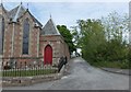
Lane by the church
Narrow lane to the northeast of the B6398, beside the Church of Scotland in Newtown St Boswells.
Image: © Barbara Carr
Taken: 3 Jun 2013
0.05 miles
4
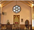
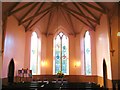
Newtown Church
Looking east in the lovely church in Roxburghshire.
Image: © James Denham
Taken: 26 Jan 2011
0.06 miles
5
The A68 at Newtown St Boswells
This was taken at the junction with the B6398 near Milestone Garden Centre.
Image: © Walter Baxter
Taken: 2 Oct 2017
0.07 miles
6
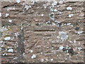
Ordnance Survey Cut Mark
This can be found on the wall of Newtown Church.
For more detail see : http://www.bench-marks.org.uk/bm72502
Image: © Peter Wood
Taken: 15 Oct 2015
0.07 miles
8
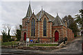
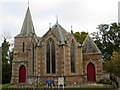
Newtown Parish Church
Church of Scotland building on the southern approach to the village of Newtown St Boswells, erected in 1868.
Image: © Walter Baxter
Taken: 29 Jan 2007
0.07 miles
10
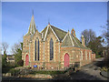
The wonderful apse-style west elevation of Newtown Church
The first church at Newtown was built as an Anti-Burgher Secession Church in the 1770s. That church was situated near the foot of the hill in the village, near the old railway station. In time, as the congregation grew, a new church was required and duly arrived in 1868, built at the top of the hill, and now a part of the United Presbyterian Church. In 1900 the congregation amalgamated with the Free Kirk to form the United Free Church before,in 1929, coming together with a reunified Church of Scotland where it remains.
Source : The Village Kirks of the Scottish Borders - 2011 : The Churches and Churchyards of Roxburghshire - G.A.C. Binnie 2001.
Image: © James Denham
Taken: 26 Jan 2011
0.08 miles