IMAGES TAKEN NEAR TO
Tower Road, BERWICK-UPON-TWEED, TD15 2BD
Introduction
This page details the photographs taken nearby to Tower Road, TD15 2BD by members of the Geograph project.
The Geograph project started in 2005 with the aim of publishing, organising and preserving representative images for every square kilometre of Great Britain, Ireland and the Isle of Man.

There are currently over 7.5m images from over14,400 individuals and you can help contribute to the project by visiting https://www.geograph.org.uk
Image Map
Images are licensed for reuse under creativecommons.org/licenses/by-sa/2.0
Notes
- Clicking on the map will re-center to the selected point.
- The higher the marker number, the further away the image location is from the centre of the postcode.
Image Listing (182 Images Found)
Images are licensed for reuse under creativecommons.org/licenses/by-sa/2.0
Image
Details
Distance
1
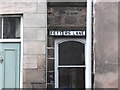
Fetters Lane
It is reputed that every fetter and shackle for the slave-trade was made at the old ironworks here.
A chilling thought.
Image: © Barbara Carr
Taken: 27 Jan 2013
0.02 miles
2
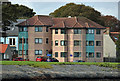
Flats at Dock Road, Tweedmouth
This telephoto shot was taken from a boat on the River Tweed.
Image: © Walter Baxter
Taken: 26 Sep 2019
0.03 miles
3
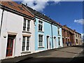
Colourful Houses at Tower Road Tweedmouth
Attractively painted houses here in Tweedmouth.
Image: © Jennifer Petrie
Taken: 9 Aug 2024
0.03 miles
7
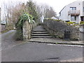
Footpath steps in Tweedmouth
A footpath runs through Tweedmouth, connecting ancient historic sites to old routes and the more modern Coastal Path.
Image: © Barbara Carr
Taken: 27 Jan 2013
0.06 miles
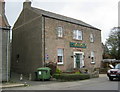
8
The Lowry Trail
The artist WS Lowry (1887-1976) was a frequent visitor to Berwick. The Lowry Trail round the town commemorates this association and displays copies of many of his paintings of the area. This is point 13 on the Trail and shows "Berwick Harbour" a pencil drawing from 1959. St Andrew's Wallace Green and Lowick Church of Scotland can be seen both in the drawing and in reality on the far side of the estuary.
Image: © Oliver Dixon
Taken: 11 Apr 2015
0.07 miles
9
Path through the Goody Patchy, Tweedmouth
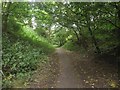
Looking along a footpath through the Goody Patchy Tweedmouth. The area is a mix of woodland and mown grass areas between the disused railway yard and Dock Road.
Image: © Graham Robson
Taken: 3 Oct 2015
0.07 miles
10
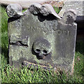
A symbolic gravestone in Tweedmouth Parish Churchyard
This memento mori (remember you must die) stone has the classic symbols of mortality in the form of a Death’s Head skull, horizontal hourglass and femur bone.
Image: © Walter Baxter
Taken: 28 Apr 2019
0.08 miles