IMAGES TAKEN NEAR TO
Stow, GALASHIELS, TD1 2RY
Introduction
This page details the photographs taken nearby to TD1 2RY by members of the Geograph project.
The Geograph project started in 2005 with the aim of publishing, organising and preserving representative images for every square kilometre of Great Britain, Ireland and the Isle of Man.

There are currently over 7.5m images from over14,400 individuals and you can help contribute to the project by visiting https://www.geograph.org.uk
Image Map
Images are licensed for reuse under creativecommons.org/licenses/by-sa/2.0
Notes
- Clicking on the map will re-center to the selected point.
- The higher the marker number, the further away the image location is from the centre of the postcode.
Image Listing (14 Images Found)
Images are licensed for reuse under creativecommons.org/licenses/by-sa/2.0
Image
Details
Distance
1
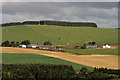
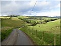
Cortleferry Farm
Viewed in September from Carsinker Law.
Image: © Walter Baxter
Taken: 17 Sep 2010
0.05 miles
2
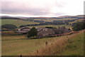
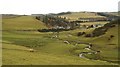
Cortleferry
Looking down over Cortleferry to the Gala Water valley.
Image: © Dougie Johnston
Taken: 10 Aug 2005
0.05 miles
3
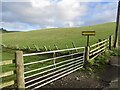
Track end, Cortleferry
Signposted for Resting House, but now has two electric fences in the way. They can be crossed, but confidence and cunning may be required. It's a lovely grassy track.
Image: © Richard Webb
Taken: 17 Oct 2022
0.07 miles
4
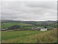
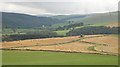
Cortleferry and Wedale
A farm above the valley of the Gala Water
Image: © M J Richardson
Taken: 14 Oct 2014
0.07 miles
6
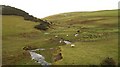
Toddle Burn
Meandering burn approaching Fountainhall and the Gala Water.
Image: © Richard Webb
Taken: 12 Feb 2010
0.16 miles
7
Toddle Burn
View up the Toddle Burn from near Cortleferry. The power station road is out of sight to the left.
Image: © Richard Webb
Taken: 12 Feb 2010
0.19 miles
8
Combine, Cortleferry
It is well into October and there is still work out there for this combine - if it stops raining.
2008 was the year of the huge grain drying bill and endless struggles to free combine harvesters stuck in barley fields disguised as paddy fields. An uncut field near here had standing water clearly visible in the tramlines.
View down the Gala Water.
Image: © Richard Webb
Taken: 7 Oct 2008
0.20 miles
9
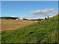
Farmland at Cortleferry
A view from some grazing sheep to a harvested field and buildings at Cortleferry Farm.
Image: © Walter Baxter
Taken: 20 Sep 2010
0.21 miles
10
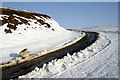
The access road to Toddleburn Wind Farm
The going on the road today was very difficult due to ice, so I walked to the side on the snow.
Image: © Walter Baxter
Taken: 17 Jan 2010
0.23 miles